
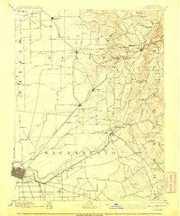
~ Sacramento CA topo map, 1:125000 scale, 30 X 30 Minute, Historical, 1892, updated 1908
Sacramento, California, USGS topographic map dated 1892.
Includes geographic coordinates (latitude and longitude). This topographic map is suitable for hiking, camping, and exploring, or framing it as a wall map.
Printed on-demand using high resolution imagery, on heavy weight and acid free paper, or alternatively on a variety of synthetic materials.
Topos available on paper, Waterproof, Poly, or Tyvek. Usually shipping rolled, unless combined with other folded maps in one order.
- Product Number: USGS-5506217
- Free digital map download (high-resolution, GeoPDF): Sacramento, California (file size: 6 MB)
- Map Size: please refer to the dimensions of the GeoPDF map above
- Weight (paper map): ca. 55 grams
- Map Type: POD USGS Topographic Map
- Map Series: HTMC
- Map Verison: Historical
- Cell ID: 66504
- Scan ID: 299593
- Imprint Year: 1908
- Survey Year: 1888
- Datum: Unstated
- Map Projection: Unstated
- Map published by United States Geological Survey
- Keywords: Overedge
- Map Language: English
- Scanner Resolution: 600 dpi
- Map Cell Name: Sacramento
- Grid size: 30 X 30 Minute
- Date on map: 1892
- Map Scale: 1:125000
- Geographical region: California, United States
Neighboring Maps:
All neighboring USGS topo maps are available for sale online at a variety of scales.
Spatial coverage:
Topo map Sacramento, California, covers the geographical area associated the following places:
- Sankey - Manlove - Summit Village - Fairoaks Bridge (historical) - Ben Ali - La Cresta Village - Lincoln - Winterhaven Village - Brighton - Fair Oaks - Gold River - La Riviera - Zee Estates - Roseville - Fruitridge Manor - Bar J Ranch - Manzanita Acres - Riego - Equestrian Village - Citrus - Malby Crossing - Bombay - Walltown - Town and Country Village - Rosemont - Saint Andrews Village - Routier (historical) - Arcade - Pilot Hill - Rio Linda - Briarwood Canyon - Glenborough - Granite Bay - Salmon Falls (historical) - North Highlands - North Sacramento - Lakeshore - Counsman - Hagginwood - East Sacramento - Governors Village - Sunset Mobile Home Park - Prairie City - Hickok Ranch - Franciscan Village - Auburn - Lake Hills Estates - Park Village - Alder Creek - Del Paso Heights - Elvas - Orangevale - Golden Chain Mobile Home Park - Swanston - Walerga - Ramona - Green Springs Ranch - Oak Ridge Village - Highland Park - Sheridan - Clipper Gap - Ridgeview Village - Marina Village - Arroyo Vista - Mayhew - Sabre City - Mather Field - South Sacramento - Cordova - Highland Village - Nielsburg - Millertown (historical) - Citrus Heights - North Auburn - Newcastle - Ophir - Carmichael - Arden Town - Clayton - Stonegate Village - Folsom - Green Valley Acres - Clarksville - Waterford Village - Crescent Ridge Village - Oak Tree Village - Auburn Hills Mobile Estates - Springfield Meadows - Lakeridge Oaks - Rocklin - Virginiatown - Ewing - Oak Park - Whitney - Salsbury (historical) - Rancho Cordova - Polk - Bowman - Rancho Murieta - Walsh Station
- Map Area ID: AREA3938.5-121.5-121
- Northwest corner Lat/Long code: USGSNW39-121.5
- Northeast corner Lat/Long code: USGSNE39-121
- Southwest corner Lat/Long code: USGSSW38.5-121.5
- Southeast corner Lat/Long code: USGSSE38.5-121
- Northern map edge Latitude: 39
- Southern map edge Latitude: 38.5
- Western map edge Longitude: -121.5
- Eastern map edge Longitude: -121


