
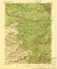
~ Mineral CA topo map, 1:125000 scale, 30 X 30 Minute, Historical, 1941, updated 1941
Mineral, California, USGS topographic map dated 1941.
Includes geographic coordinates (latitude and longitude). This topographic map is suitable for hiking, camping, and exploring, or framing it as a wall map.
Printed on-demand using high resolution imagery, on heavy weight and acid free paper, or alternatively on a variety of synthetic materials.
Topos available on paper, Waterproof, Poly, or Tyvek. Usually shipping rolled, unless combined with other folded maps in one order.
- Product Number: USGS-5505993
- Free digital map download (high-resolution, GeoPDF): Mineral, California (file size: 10 MB)
- Map Size: please refer to the dimensions of the GeoPDF map above
- Weight (paper map): ca. 55 grams
- Map Type: POD USGS Topographic Map
- Map Series: HTMC
- Map Verison: Historical
- Cell ID: 66061
- Scan ID: 299461
- Imprint Year: 1941
- Woodland Tint: Yes
- Survey Year: 1935
- Datum: NAD27
- Map Projection: Polyconic
- Map published by United States Geological Survey
- Map Language: English
- Scanner Resolution: 600 dpi
- Map Cell Name: Mineral
- Grid size: 30 X 30 Minute
- Date on map: 1941
- Map Scale: 1:125000
- Geographical region: California, United States
Neighboring Maps:
All neighboring USGS topo maps are available for sale online at a variety of scales.
Spatial coverage:
Topo map Mineral, California, covers the geographical area associated the following places:
- Facht Place - Savercool Place - Glenburn - McClure Place - Wells Place - Favinger Place - Paynes Creek - Butte Meadows - Shingletown - Meyers Place - Avery Place - Lyman Springs - Yellowjacket - Buena Vista - Lyonsville - Peligreen Place - Pape Place - Mill Creek - Lomo - Finley Place - Payne Place - Mineral - Campbellville - Morgan Springs - Tenmile (historical) - Wade Place - McKenzie Place - Thompson Place - Manton - Dantuma Place - Summerville (historical) - Roberts Place - Polk Springs - Marian Place
- Map Area ID: AREA40.540-122-121.5
- Northwest corner Lat/Long code: USGSNW40.5-122
- Northeast corner Lat/Long code: USGSNE40.5-121.5
- Southwest corner Lat/Long code: USGSSW40-122
- Southeast corner Lat/Long code: USGSSE40-121.5
- Northern map edge Latitude: 40.5
- Southern map edge Latitude: 40
- Western map edge Longitude: -122
- Eastern map edge Longitude: -121.5


