
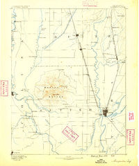
~ Marysville CA topo map, 1:125000 scale, 30 X 30 Minute, Historical, 1888, updated 1888
Marysville, California, USGS topographic map dated 1888.
Includes geographic coordinates (latitude and longitude). This topographic map is suitable for hiking, camping, and exploring, or framing it as a wall map.
Printed on-demand using high resolution imagery, on heavy weight and acid free paper, or alternatively on a variety of synthetic materials.
Topos available on paper, Waterproof, Poly, or Tyvek. Usually shipping rolled, unless combined with other folded maps in one order.
- Product Number: USGS-5505969
- Free digital map download (high-resolution, GeoPDF): Marysville, California (file size: 4 MB)
- Map Size: please refer to the dimensions of the GeoPDF map above
- Weight (paper map): ca. 55 grams
- Map Type: POD USGS Topographic Map
- Map Series: HTMC
- Map Verison: Historical
- Cell ID: 66000
- Scan ID: 299448
- Imprint Year: 1888
- Survey Year: 1886
- Datum: Unstated
- Map Projection: Unstated
- Map published by United States Geological Survey
- Map Language: English
- Scanner Resolution: 600 dpi
- Map Cell Name: Marysville
- Grid size: 30 X 30 Minute
- Date on map: 1888
- Map Scale: 1:125000
- Geographical region: California, United States
Neighboring Maps:
All neighboring USGS topo maps are available for sale online at a variety of scales.
Spatial coverage:
Topo map Marysville, California, covers the geographical area associated the following places:
- Grand Island - East Arboga - Peachton - Dean Place - Peach Mobile Estates - Dantoni - Craig - Vista Robles - Bliss (historical) - Colusa Junction - East Gridley - Honcut - Pease (historical) - Live Oak - Stafford (historical) - Olivehurst - Lira - Alemandra - Meridian - Oswald - Robinsons Corner - Arboga - South Oroville - Mendoza (historical) - Sutter - Arbee - Fraziers Landing - Tambo - Tisdale - Berg - Grimes - Riviera (historical) - Vinboy Trailer Park - Ostrom - Alpine Village Mobile Home Estates - Bihlman (historical) - Alicia - Coombs (historical) - Thunderbird Mobile Home Park - Palermo - Hinsdale - Sunset - Gridley Colony Number One (historical) - Oliver (historical) - West Linda - Oak Grove - Richland (historical) - West Butte - Butte House (historical) - Tierra Buena - Chandon (historical) - Sanders - Castlewood Mobile Home Park - Hume (historical) - The Garden Mobile Home Park - Biggs - Gridley Colony Number Two (historical) - Graino - Pearson - Abbott - Bogue - Haselbusch (historical) - Tarke - South Yuba - Pennington - Sullivan - Riceton - Casa Mia Mobile Home Park - Yupu (historical) - Lorraine (historical) - Progress - Villa Seville Mobile Home Park - Marysville - Mount Vernon - Lava Beds (historical) - Encinal - Plumas Lake - Afton - Butte City - Joesphine - South Yuba City - Yuba Mobile Home Park - Lomo - Sycamore - Binney Junction - Linda - Fagan - Gridley - Country Side Mobile Home Park - Yuba City - Mello - East Biggs - Tudor - Richvale - Ramirez - Nuestro - Yuba (historical)
- Map Area ID: AREA39.539-122-121.5
- Northwest corner Lat/Long code: USGSNW39.5-122
- Northeast corner Lat/Long code: USGSNE39.5-121.5
- Southwest corner Lat/Long code: USGSSW39-122
- Southeast corner Lat/Long code: USGSSE39-121.5
- Northern map edge Latitude: 39.5
- Southern map edge Latitude: 39
- Western map edge Longitude: -122
- Eastern map edge Longitude: -121.5


