
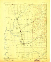
~ Lodi CA topo map, 1:125000 scale, 30 X 30 Minute, Historical, 1894, updated 1906
Lodi, California, USGS topographic map dated 1894.
Includes geographic coordinates (latitude and longitude). This topographic map is suitable for hiking, camping, and exploring, or framing it as a wall map.
Printed on-demand using high resolution imagery, on heavy weight and acid free paper, or alternatively on a variety of synthetic materials.
Topos available on paper, Waterproof, Poly, or Tyvek. Usually shipping rolled, unless combined with other folded maps in one order.
- Product Number: USGS-5505925
- Free digital map download (high-resolution, GeoPDF): Lodi, California (file size: 5 MB)
- Map Size: please refer to the dimensions of the GeoPDF map above
- Weight (paper map): ca. 55 grams
- Map Type: POD USGS Topographic Map
- Map Series: HTMC
- Map Verison: Historical
- Cell ID: 65924
- Scan ID: 299419
- Imprint Year: 1906
- Survey Year: 1891
- Datum: Unstated
- Map Projection: Unstated
- Map published by United States Geological Survey
- Map Language: English
- Scanner Resolution: 600 dpi
- Map Cell Name: Lodi
- Grid size: 30 X 30 Minute
- Date on map: 1894
- Map Scale: 1:125000
- Geographical region: California, United States
Neighboring Maps:
All neighboring USGS topo maps are available for sale online at a variety of scales.
Spatial coverage:
Topo map Lodi, California, covers the geographical area associated the following places:
- Lane - Linden - Tomspur - Collierville - Guild - Carbondale - Fallbrook - Dougherty - Henderson Village - New Hope - Conley (historical) - Walmort - Centralia - Bear Creek - Pollock - Laguna - Cicero (historical) - Ampere - Twin Cities - Dogtown - Laguna West - Victor - Hawes - Arno (historical) - Galt - Youngstown - Lockeford - Kettleman - Sheldon - Franklin - Parkway - Lodi - Villinger - Point Pleasant - East Side - Monada - Florin - Waterloo - Bellota - Live Oak - Hicksville - Michigan Bar (historical) - Roma - Peltier - Lincoln Village - Camden - Norton - Sloughhouse - Pope - Dillard - Armstrong - Clements - May (historical) - Elliott (historical) - Cosumne - Elk Grove - Bruceville - Morada - Haight - Coffing - Herald - Taison (historical) - Woodbridge - New Hope Landing - Acampo - Cherokee - Vineyard - Lodi Junction - Need - Foppiano - Urgon - Thornton - Mokelumne City - Clay - Woodlake - Oo-moo-chah (historical) - Graham (historical) - Terminous - Wilton - Pearson
- Map Area ID: AREA38.538-121.5-121
- Northwest corner Lat/Long code: USGSNW38.5-121.5
- Northeast corner Lat/Long code: USGSNE38.5-121
- Southwest corner Lat/Long code: USGSSW38-121.5
- Southeast corner Lat/Long code: USGSSE38-121
- Northern map edge Latitude: 38.5
- Southern map edge Latitude: 38
- Western map edge Longitude: -121.5
- Eastern map edge Longitude: -121


