
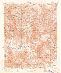
~ Kernville CA topo map, 1:125000 scale, 30 X 30 Minute, Historical, 1908, updated 1934
Kernville, California, USGS topographic map dated 1908.
Includes geographic coordinates (latitude and longitude). This topographic map is suitable for hiking, camping, and exploring, or framing it as a wall map.
Printed on-demand using high resolution imagery, on heavy weight and acid free paper, or alternatively on a variety of synthetic materials.
Topos available on paper, Waterproof, Poly, or Tyvek. Usually shipping rolled, unless combined with other folded maps in one order.
- Product Number: USGS-5505915
- Free digital map download (high-resolution, GeoPDF): Kernville, California (file size: 12 MB)
- Map Size: please refer to the dimensions of the GeoPDF map above
- Weight (paper map): ca. 55 grams
- Map Type: POD USGS Topographic Map
- Map Series: HTMC
- Map Verison: Historical
- Cell ID: 65800
- Scan ID: 299413
- Imprint Year: 1934
- Survey Year: 1906
- Datum: NAD
- Map Projection: Polyconic
- Map published by United States Geological Survey
- Map Language: English
- Scanner Resolution: 600 dpi
- Map Cell Name: Kernville
- Grid size: 30 X 30 Minute
- Date on map: 1908
- Map Scale: 1:125000
- Geographical region: California, United States
Neighboring Maps:
All neighboring USGS topo maps are available for sale online at a variety of scales.
Spatial coverage:
Topo map Kernville, California, covers the geographical area associated the following places:
- Scovern Hot Springs (historical) - Mountain Mesa - Isabella (historical) - Canebrake (historical) - Lake Isabella - Bodfish - Kernville - Riverkern - Bella Vista - Roads End - Camp Owens - Wofford Heights - South Lake - Moreland Mill - Kernville (historical) - Onyx - Fairview - Canebrake - Squirrel Mountain Valley - Weldon - Burton Mill
- Map Area ID: AREA3635.5-118.5-118
- Northwest corner Lat/Long code: USGSNW36-118.5
- Northeast corner Lat/Long code: USGSNE36-118
- Southwest corner Lat/Long code: USGSSW35.5-118.5
- Southeast corner Lat/Long code: USGSSE35.5-118
- Northern map edge Latitude: 36
- Southern map edge Latitude: 35.5
- Western map edge Longitude: -118.5
- Eastern map edge Longitude: -118


