
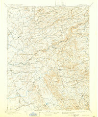
~ Jackson CA topo map, 1:125000 scale, 30 X 30 Minute, Historical, 1902, updated 1932
Jackson, California, USGS topographic map dated 1902.
Includes geographic coordinates (latitude and longitude). This topographic map is suitable for hiking, camping, and exploring, or framing it as a wall map.
Printed on-demand using high resolution imagery, on heavy weight and acid free paper, or alternatively on a variety of synthetic materials.
Topos available on paper, Waterproof, Poly, or Tyvek. Usually shipping rolled, unless combined with other folded maps in one order.
- Product Number: USGS-5505867
- Free digital map download (high-resolution, GeoPDF): Jackson, California (file size: 8 MB)
- Map Size: please refer to the dimensions of the GeoPDF map above
- Weight (paper map): ca. 55 grams
- Map Type: POD USGS Topographic Map
- Map Series: HTMC
- Map Verison: Historical
- Cell ID: 65746
- Scan ID: 299388
- Imprint Year: 1932
- Survey Year: 1888
- Datum: Unstated
- Map Projection: Polyconic
- Map published by United States Geological Survey
- Map Language: English
- Scanner Resolution: 600 dpi
- Map Cell Name: Jackson
- Grid size: 30 X 30 Minute
- Date on map: 1902
- Map Scale: 1:125000
- Geographical region: California, United States
Neighboring Maps:
All neighboring USGS topo maps are available for sale online at a variety of scales.
Spatial coverage:
Topo map Jackson, California, covers the geographical area associated the following places:
- Clarsona - Oak Grove - Camanche Village - Fourth Crossing - Scottsville - Goodmans Corner - Buckhorn - Clinton - Pine Grove - Alabama Hill - Plymouth - Carson Hill - Pokerville (historical) - Rich Gulch - Ione - Ranch House Estates - Valley Springs - Electra - Lake Camanche Ranches - Felix - Volcano - Camanche (historical) - Lancha Plana (historical) - Independence - Sunnybrook - Bummerville - Jesus Maria - Jackson - Scenic Valley Ranchos - Dagon - Lower Rancheria (historical) - Bunker Hill - Mountain Ranch - Big Bar - Irishtown (historical) - Toyanza Subdivision - Toyon - Wilseyville - Pioneer - Oak Park Estates - Norval (historical) - Campo Seco - Happy Valley - Quail Oaks - Pine Acres - San Andreas - Milton - Sandy Gulch - Sutter Creek - Cave City - West Point - Sutter Hill - Edwin - Barton - Mountain Ranch Subdivision - Chinatown (historical) - South Camanche Shore - Bonnefoy - Rail Road Flat - Amador City - Lost City - New Chicago - Forest Home (historical) - Burson - Camp Pardee - Firebrick - Wallace - Paloma - Angels Camp - Calaveritas - Mokelumne Hill - Milligan District (historical) - Rancho Calaveras - Glencoe - Altaville - Carmen City - Mother Lode Acres - Martell - Lynn Park Acres - Buena Vista - Drytown - Jenny Lind
- Map Area ID: AREA38.538-121-120.5
- Northwest corner Lat/Long code: USGSNW38.5-121
- Northeast corner Lat/Long code: USGSNE38.5-120.5
- Southwest corner Lat/Long code: USGSSW38-121
- Southeast corner Lat/Long code: USGSSE38-120.5
- Northern map edge Latitude: 38.5
- Southern map edge Latitude: 38
- Western map edge Longitude: -121
- Eastern map edge Longitude: -120.5


