
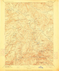
~ Downieville CA topo map, 1:125000 scale, 30 X 30 Minute, Historical, 1897, updated 1912
Downieville, California, USGS topographic map dated 1897.
Includes geographic coordinates (latitude and longitude). This topographic map is suitable for hiking, camping, and exploring, or framing it as a wall map.
Printed on-demand using high resolution imagery, on heavy weight and acid free paper, or alternatively on a variety of synthetic materials.
Topos available on paper, Waterproof, Poly, or Tyvek. Usually shipping rolled, unless combined with other folded maps in one order.
- Product Number: USGS-5505779
- Free digital map download (high-resolution, GeoPDF): Downieville, California (file size: 9 MB)
- Map Size: please refer to the dimensions of the GeoPDF map above
- Weight (paper map): ca. 55 grams
- Map Type: POD USGS Topographic Map
- Map Series: HTMC
- Map Verison: Historical
- Cell ID: 320675
- Scan ID: 299335
- Imprint Year: 1912
- Survey Year: 1888
- Datum: Unstated
- Map Projection: Unstated
- Map published by United States Geological Survey
- Map Language: English
- Scanner Resolution: 600 dpi
- Map Cell Name: Downieville
- Grid size: 30 X 30 Minute
- Date on map: 1897
- Map Scale: 1:125000
- Geographical region: California, United States
Neighboring Maps:
All neighboring USGS topo maps are available for sale online at a variety of scales.
Spatial coverage:
Topo map Downieville, California, covers the geographical area associated the following places:
- Gibsonville - Sloat - Feather River Park - English Bar (historical) - Quincy Junction - Carvin Creek Homesites - Deadwood (historical) - Maredith Mill - Lovejoy (historical) - Clio - Dentens (historical) - Goodyears Bar - Bassetts - Mount Pleasant - Plumas Eureka (historical) - Mabie - La Porte - Indian Hill (historical) - Bells Bar (historical) - McMahons (historical) - Greenhorn - Gate Place - Eureka (historical) - Mohawk - Bontes (historical) - Sierra City - Haskell Creek Homesites - Walkermine (historical) - Saint Louis - Howland Flat - Little Jamison (historical) - Oxford Mill - Blairsden - Five Points - Squirrel Creek (historical) - Milton (historical) - East Quincy - Delaney (historical) - Cromberg - Queen City - Silongkoyo (historical) - Whitehawk - Middle Waters (historical) - Mohawk Vista - Jamison (historical) - Quincy - Valley Ranch - Two Rivers - Plumas Eureka - Grass Flat - Morristown - Downieville - Cedar Mill - Mount Vernon (historical) - Johnsville - Chases (historical) - Scales - Massack - Feather River Inn - Little Grass Valley - Argentine (historical) - Spring Garden - Loganville - Monte Cristo (historical) - Poker Flat - Graeagle
- Map Area ID: AREA4039.5-121-120.5
- Northwest corner Lat/Long code: USGSNW40-121
- Northeast corner Lat/Long code: USGSNE40-120.5
- Southwest corner Lat/Long code: USGSSW39.5-121
- Southeast corner Lat/Long code: USGSSE39.5-120.5
- Northern map edge Latitude: 40
- Southern map edge Latitude: 39.5
- Western map edge Longitude: -121
- Eastern map edge Longitude: -120.5


