
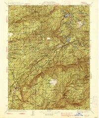
~ Colfax CA topo map, 1:125000 scale, 30 X 30 Minute, Historical, 1938, updated 1938
Colfax, California, USGS topographic map dated 1938.
Includes geographic coordinates (latitude and longitude). This topographic map is suitable for hiking, camping, and exploring, or framing it as a wall map.
Printed on-demand using high resolution imagery, on heavy weight and acid free paper, or alternatively on a variety of synthetic materials.
Topos available on paper, Waterproof, Poly, or Tyvek. Usually shipping rolled, unless combined with other folded maps in one order.
- Product Number: USGS-5505711
- Free digital map download (high-resolution, GeoPDF): Colfax, California (file size: 12 MB)
- Map Size: please refer to the dimensions of the GeoPDF map above
- Weight (paper map): ca. 55 grams
- Map Type: POD USGS Topographic Map
- Map Series: HTMC
- Map Verison: Historical
- Cell ID: 65237
- Scan ID: 299298
- Imprint Year: 1938
- Woodland Tint: Yes
- Survey Year: 1887
- Datum: NAD27
- Map Projection: Polyconic
- Map published by United States Geological Survey
- Map Language: English
- Scanner Resolution: 600 dpi
- Map Cell Name: Colfax
- Grid size: 30 X 30 Minute
- Date on map: 1938
- Map Scale: 1:125000
- Geographical region: California, United States
Neighboring Maps:
All neighboring USGS topo maps are available for sale online at a variety of scales.
Spatial coverage:
Topo map Colfax, California, covers the geographical area associated the following places:
- Baltimore (historical) - Bath (historical) - Willow Valley - Remington Hill (historical) - Colfax - Drum (historical) - Secret Canyon (historical) - Unionville (historical) - Eagle Bird (historical) - Cisco Grove - Little York (historical) - Midas - Baltimore Town - Goggins (historical) - Alpha (historical) - Relief - Shady Glen - Ralston (historical) - Michigan Bluff - Forebay - Big Bend - Flat Ravine (historical) - Dillon (historical) - Forest - Marsh Mill - Lander Crossing - Blue Canyon - North Bloomfield - Minnesota Flat - Rawhide - Goggins - Magra - Gold Run - Malakoff (historical) - Cape Horn - North Columbia - Twin Pines - Monte Vista - Camp Spaulding - Towle - Alta - Casa Loma - Lake City - Crystal Lake - Blue Tent - Crystal Springs (historical) - Foresthill - Bear River Pines - Emigrant Gap - Snow Point (historical) - Peardale - Graniteville - Pike - Mayflower (historical) - Eden Valley - Yuba Pass - Orleans Flat - Cascade Shores - Summit City (historical) - Westville - Maybert (historical) - Centerville (historical) - Grizzly Gulch (historical) - Omega - Plumbago - Tippecanoe (historical) - Langs (historical) - Snow Tent (historical) - Cold Spring (historical) - Washington - Secret Town - Four Acres - You Bet - Baxter - Quaker Hill (historical) - Red Point (historical) - Hughes Mill - Gaston - Hunts Hill (historical) - Bear Valley (historical) - Greekstore (historical) - Pinecroft - Moores Flat - Cisco - Dutch Flat - Coleman - Yankee Jims - Illinoistown (historical) - Rainbow - Deer Creek Park - Red Dog - Woolsey Flat - Weimar - Plum Valley - Iowa Hill - Applegate - Pinecrest - Shands (historical) - Junction House - Last Chance
- Map Area ID: AREA39.539-121-120.5
- Northwest corner Lat/Long code: USGSNW39.5-121
- Northeast corner Lat/Long code: USGSNE39.5-120.5
- Southwest corner Lat/Long code: USGSSW39-121
- Southeast corner Lat/Long code: USGSSE39-120.5
- Northern map edge Latitude: 39.5
- Southern map edge Latitude: 39
- Western map edge Longitude: -121
- Eastern map edge Longitude: -120.5


