
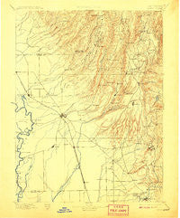
~ Chico CA topo map, 1:125000 scale, 30 X 30 Minute, Historical, 1895, updated 1908
Chico, California, USGS topographic map dated 1895.
Includes geographic coordinates (latitude and longitude). This topographic map is suitable for hiking, camping, and exploring, or framing it as a wall map.
Printed on-demand using high resolution imagery, on heavy weight and acid free paper, or alternatively on a variety of synthetic materials.
Topos available on paper, Waterproof, Poly, or Tyvek. Usually shipping rolled, unless combined with other folded maps in one order.
- Product Number: USGS-5505659
- Free digital map download (high-resolution, GeoPDF): Chico, California (file size: 8 MB)
- Map Size: please refer to the dimensions of the GeoPDF map above
- Weight (paper map): ca. 55 grams
- Map Type: POD USGS Topographic Map
- Map Series: HTMC
- Map Verison: Historical
- Cell ID: 72133
- Scan ID: 299272
- Imprint Year: 1908
- Survey Year: 1888
- Datum: Unstated
- Map Projection: Unstated
- Map published by United States Geological Survey
- Map Language: English
- Scanner Resolution: 600 dpi
- Map Cell Name: Chico
- Grid size: 30 X 30 Minute
- Date on map: 1895
- Map Scale: 1:125000
- Geographical region: California, United States
Neighboring Maps:
All neighboring USGS topo maps are available for sale online at a variety of scales.
Spatial coverage:
Topo map Chico, California, covers the geographical area associated the following places:
- De Sabla - Dodge Place - Centerville - Oroville - Chapmantown - Oroville Junction - Oregon City - Nimshew - Toadtown - Nelson - Powellton - Stirling Junction - Blavo - Mineral Slide - Monroeville (historical) - Michopdo (historical) - Inskip - Paradise Pines - Pentz - Paradise - Elsey - Richardson Springs - Irish Town - Ramada - Kramm - Cherokee - Dodgeland - Yuman (historical) - Cohasset - Deadwood - Helltown - Lovelock - Magalia - Nelson Bar (historical) - Anita - Dayton - Forest Ranch - Barber - Concow - DeSabla - Eskini (historical) - Esquon - Rancho Llano Seco - Nord - Shippee - James - Roble - Stirling City - Cana - Thermalito - Wicks Corner - Yankee Hill - Durham - Chico
- Map Area ID: AREA4039.5-122-121.5
- Northwest corner Lat/Long code: USGSNW40-122
- Northeast corner Lat/Long code: USGSNE40-121.5
- Southwest corner Lat/Long code: USGSSW39.5-122
- Southeast corner Lat/Long code: USGSSE39.5-121.5
- Northern map edge Latitude: 40
- Southern map edge Latitude: 39.5
- Western map edge Longitude: -122
- Eastern map edge Longitude: -121.5


