
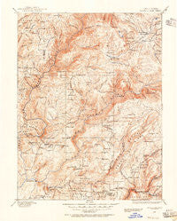
~ Bidwell Bar CA topo map, 1:125000 scale, 30 X 30 Minute, Historical, 1888, updated 1956
Bidwell Bar, California, USGS topographic map dated 1888.
Includes geographic coordinates (latitude and longitude). This topographic map is suitable for hiking, camping, and exploring, or framing it as a wall map.
Printed on-demand using high resolution imagery, on heavy weight and acid free paper, or alternatively on a variety of synthetic materials.
Topos available on paper, Waterproof, Poly, or Tyvek. Usually shipping rolled, unless combined with other folded maps in one order.
- Product Number: USGS-5505539
- Free digital map download (high-resolution, GeoPDF): Bidwell Bar, California (file size: 11 MB)
- Map Size: please refer to the dimensions of the GeoPDF map above
- Weight (paper map): ca. 55 grams
- Map Type: POD USGS Topographic Map
- Map Series: HTMC
- Map Verison: Historical
- Cell ID: 64992
- Scan ID: 299212
- Imprint Year: 1956
- Survey Year: 1885
- Datum: NAD
- Map Projection: Polyconic
- Map published by United States Geological Survey
- Map Language: English
- Scanner Resolution: 600 dpi
- Map Cell Name: Bidwell Bar
- Grid size: 30 X 30 Minute
- Date on map: 1888
- Map Scale: 1:125000
- Geographical region: California, United States
Neighboring Maps:
All neighboring USGS topo maps are available for sale online at a variety of scales.
Spatial coverage:
Topo map Bidwell Bar, California, covers the geographical area associated the following places:
- Rogerville - Cal-Ida - Tobin - Rock Crest - Flea Valley (historical) - David (historical) - Storrie - Brush (historical) - Bucks Lake - Gold Lake (historical) - Feather Falls - Quartz (historical) - South Fork (historical) - Meadow Valley - New Blinzing (historical) - Palmetto - Paulson Place - Buckeye - Nelsons Crossing - Hawk Ravine (historical) - Merlin - Bucks Lodge - Big Bar - Union Hill - Bloomer (historical) - Oroleve - North Star - Bidwell (historical) - Woodleaf - Parkhill - Hughes Place - Edmanton (historical) - Cresta - Camp Eighteen - Poverty Hill - Spanish Ranch - Cascade - Rock Creek Camp - Old Forbestown - Moseley (historical) - Forbestown - Eagleville - Brush Creek - Las Plumas (historical) - Strawberry Valley - Junction House - Wagners (historical) - Pulga - Rodgers Flat - Mount Hope House (historical) - Blinzing (historical) - Kister - Big Bend - Land (historical) - Pipers (historical) - Lumpkin - Isaiah (historical) - Rock Creek - Lasslys (historical) - Mayaro - Silver Creek (historical) - Big Ripples (historical) - China Gulch (historical) - Bidwell Bar (historical) - Clipper Mills - Merrimac - Berry Creek - Enterprise (historical) - Brandy City - Poe - Craig (historical)
- Map Area ID: AREA4039.5-121.5-121
- Northwest corner Lat/Long code: USGSNW40-121.5
- Northeast corner Lat/Long code: USGSNE40-121
- Southwest corner Lat/Long code: USGSSW39.5-121.5
- Southeast corner Lat/Long code: USGSSE39.5-121
- Northern map edge Latitude: 40
- Southern map edge Latitude: 39.5
- Western map edge Longitude: -121.5
- Eastern map edge Longitude: -121


