
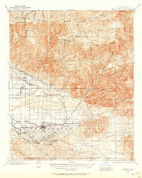
~ Redlands CA topo map, 1:62500 scale, 15 X 15 Minute, Historical, 1899, updated 1958
Redlands, California, USGS topographic map dated 1899.
Includes geographic coordinates (latitude and longitude). This topographic map is suitable for hiking, camping, and exploring, or framing it as a wall map.
Printed on-demand using high resolution imagery, on heavy weight and acid free paper, or alternatively on a variety of synthetic materials.
Topos available on paper, Waterproof, Poly, or Tyvek. Usually shipping rolled, unless combined with other folded maps in one order.
- Product Number: USGS-5503943
- Free digital map download (high-resolution, GeoPDF): Redlands, California (file size: 11 MB)
- Map Size: please refer to the dimensions of the GeoPDF map above
- Weight (paper map): ca. 55 grams
- Map Type: POD USGS Topographic Map
- Map Series: HTMC
- Map Verison: Historical
- Cell ID: 61527
- Scan ID: 298746
- Imprint Year: 1958
- Survey Year: 1899
- Datum: Unstated
- Map Projection: Polyconic
- Map published by United States Geological Survey
- Map Language: English
- Scanner Resolution: 600 dpi
- Map Cell Name: Redlands
- Grid size: 15 X 15 Minute
- Date on map: 1899
- Map Scale: 1:62500
- Geographical region: California, United States
Neighboring Maps:
All neighboring USGS topo maps are available for sale online at a variety of scales.
Spatial coverage:
Topo map Redlands, California, covers the geographical area associated the following places:
- Rimforest - Running Springs - Twin Peaks - Green Valley Lake - Warm Springs - Amber Hills - Lake Arrowhead - Fredalba - Greenspot (historical) - Meadowbrook Woods - Crest Park - Mentone - Smiley Heights - Warner - Redlands Heights - Plymouth Village - Crafton - Blue Jay - Arrowbear Lake - Calimesa - Yucaipa - Agua Fria - West Highlands - Lugonia Homes - Redlands - Ordway - Smiley Park - Molino - Harlem Springs - Dunlap Acres - Nevada - Highland - Browns (historical) - Del Rosa - Patton - Bryn Mawr - East Highlands - Marigold - Skyforest - Sunkist - Crown Jewel - University Village - North Bench
- Map Area ID: AREA34.2534-117.25-117
- Northwest corner Lat/Long code: USGSNW34.25-117.25
- Northeast corner Lat/Long code: USGSNE34.25-117
- Southwest corner Lat/Long code: USGSSW34-117.25
- Southeast corner Lat/Long code: USGSSE34-117
- Northern map edge Latitude: 34.25
- Southern map edge Latitude: 34
- Western map edge Longitude: -117.25
- Eastern map edge Longitude: -117


