
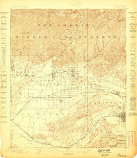
~ Pomona CA topo map, 1:62500 scale, 15 X 15 Minute, Historical, 1898
Pomona, California, USGS topographic map dated 1898.
Includes geographic coordinates (latitude and longitude). This topographic map is suitable for hiking, camping, and exploring, or framing it as a wall map.
Printed on-demand using high resolution imagery, on heavy weight and acid free paper, or alternatively on a variety of synthetic materials.
Topos available on paper, Waterproof, Poly, or Tyvek. Usually shipping rolled, unless combined with other folded maps in one order.
- Product Number: USGS-5503745
- Free digital map download (high-resolution, GeoPDF): Pomona, California (file size: 9 MB)
- Map Size: please refer to the dimensions of the GeoPDF map above
- Weight (paper map): ca. 55 grams
- Map Type: POD USGS Topographic Map
- Map Series: HTMC
- Map Verison: Historical
- Cell ID: 61142
- Scan ID: 298632
- Survey Year: 1894
- Datum: Unstated
- Map Projection: Unstated
- Map published by United States Geological Survey
- Map Language: English
- Scanner Resolution: 600 dpi
- Map Cell Name: Pomona
- Grid size: 15 X 15 Minute
- Date on map: 1898
- Map Scale: 1:62500
- Geographical region: California, United States
Neighboring Maps:
All neighboring USGS topo maps are available for sale online at a variety of scales.
Spatial coverage:
Topo map Pomona, California, covers the geographical area associated the following places:
- La Puente - Pomona Islander Mobile Home Park - Baldwin Park - Covina - Charter Oak Mobile Estates - Butler - Duarte - Hillgrove - Kincaid - Spadra - Cloverleaf Canyon - Lone Hill Manor Mobile Home Park - La Fetra - Orange Avenue Junction - Bassett - Glendora - Rowland - Irwindale - Las Lomas - Citrus - Walnut Hills Mobile Home Park - Charter Oak - Walnut - Monrovia - West Puente Valley - Woodside Village - Azusa - San Dimas - La Verne - West Covina - North Pomona - Industry - Puente Junction - Marne - Diamond Bar - Pomona - South San Jose Hills - Valinda - Avocado Heights - Bradbury
- Map Area ID: AREA34.2534-118-117.75
- Northwest corner Lat/Long code: USGSNW34.25-118
- Northeast corner Lat/Long code: USGSNE34.25-117.75
- Southwest corner Lat/Long code: USGSSW34-118
- Southeast corner Lat/Long code: USGSSE34-117.75
- Northern map edge Latitude: 34.25
- Southern map edge Latitude: 34
- Western map edge Longitude: -118
- Eastern map edge Longitude: -117.75


