
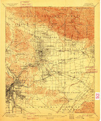
~ Pasadena CA topo map, 1:62500 scale, 15 X 15 Minute, Historical, 1900, updated 1910
Pasadena, California, USGS topographic map dated 1900.
Includes geographic coordinates (latitude and longitude). This topographic map is suitable for hiking, camping, and exploring, or framing it as a wall map.
Printed on-demand using high resolution imagery, on heavy weight and acid free paper, or alternatively on a variety of synthetic materials.
Topos available on paper, Waterproof, Poly, or Tyvek. Usually shipping rolled, unless combined with other folded maps in one order.
- Product Number: USGS-5503561
- Free digital map download (high-resolution, GeoPDF): Pasadena, California (file size: 10 MB)
- Map Size: please refer to the dimensions of the GeoPDF map above
- Weight (paper map): ca. 55 grams
- Map Type: POD USGS Topographic Map
- Map Series: HTMC
- Map Verison: Historical
- Cell ID: 60786
- Scan ID: 298503
- Imprint Year: 1910
- Survey Year: 1894
- Datum: Unstated
- Map Projection: Unstated
- Map published by United States Geological Survey
- Map Language: English
- Scanner Resolution: 600 dpi
- Map Cell Name: Pasadena
- Grid size: 15 X 15 Minute
- Date on map: 1900
- Map Scale: 1:62500
- Geographical region: California, United States
Neighboring Maps:
All neighboring USGS topo maps are available for sale online at a variety of scales.
Spatial coverage:
Topo map Pasadena, California, covers the geographical area associated the following places:
- South Pasadena - Newton Park - San Gabriel - Pasadena - North El Monte - Pico Gardens - Whittier Junction - Wyvernwood - Highland Park - Altadena - Soto Street Junction - Los Angeles - Ramona Gardens - Maravilla - Montrose - Shorb - La Cañada Flintridge - Ramona Park - New Chinatown - Butte Street Junction - East Los Angeles - Brooklyn Heights - Raymond Hill - Linda Vista - Commerce - Bandini - Boston Heights - El Sereno - Aurant - Nevin - City Terrace - Ninth Street Junction - Eagle Rock - El Monte - Wilmar - Mission Junction - East Arcadia - Chapman - Bartolo - Naud Junction - Bartolo (historical) - San Marino - Sparr Heights - Montebello - Glassell Park - Santa Anita - Clement Junction - Olga - Lamanda Park - Cypress Park - Boyle Heights - Monterey Park - Wellington Heights - Garvanza - South El Monte - South San Gabriel - West Arcadia - Briggs Terrace - Eastmont - Temple City - Verdugo City - Sierra Vista - Aliso Village - Happy Valley - Little Tokyo - Glendale Junction - North Highland Park - Vernon - Omaha Heights - Kinneloa Mesa - Maravilla Housing Project - Mount Washington - Oak Knoll - Hobart - Old Chinatown (historical) - Redondo Junction - Taylor Junction - East San Gabriel - Arcadia - Alhambra - Rose Hill - Adams Square - Maxson - La Crescenta - Savannah (historical) - Sierra Madre - Rosemead - Clayton (historical) - Five Points - Mount Wilson - Mayflower Village - Sibagna (historical) - Baird Park - Belvedere - Altacanyada - Stoneman - Lincoln Heights - Belvedere Gardens - East Pasadena - Winter Gardens
- Map Area ID: AREA34.2534-118.25-118
- Northwest corner Lat/Long code: USGSNW34.25-118.25
- Northeast corner Lat/Long code: USGSNE34.25-118
- Southwest corner Lat/Long code: USGSSW34-118.25
- Southeast corner Lat/Long code: USGSSE34-118
- Northern map edge Latitude: 34.25
- Southern map edge Latitude: 34
- Western map edge Longitude: -118.25
- Eastern map edge Longitude: -118


