
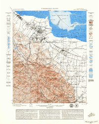
~ Palo Alto CA topo map, 1:62500 scale, 15 X 15 Minute, Historical, 1899
Palo Alto, California, USGS topographic map dated 1899.
Includes geographic coordinates (latitude and longitude). This topographic map is suitable for hiking, camping, and exploring, or framing it as a wall map.
Printed on-demand using high resolution imagery, on heavy weight and acid free paper, or alternatively on a variety of synthetic materials.
Topos available on paper, Waterproof, Poly, or Tyvek. Usually shipping rolled, unless combined with other folded maps in one order.
- Product Number: USGS-5503481
- Free digital map download (high-resolution, GeoPDF): Palo Alto, California (file size: 12 MB)
- Map Size: please refer to the dimensions of the GeoPDF map above
- Weight (paper map): ca. 55 grams
- Map Type: POD USGS Topographic Map
- Map Series: HTMC
- Map Verison: Historical
- Cell ID: 60730
- Scan ID: 298461
- Visual Version Number: 2
- Survey Year: 1895
- Datum: Unstated
- Map Projection: Unstated
- Map published by United States Geological Survey
- Map Language: English
- Scanner Resolution: 600 dpi
- Map Cell Name: Palto Alto
- Grid size: 15 X 15 Minute
- Date on map: 1899
- Map Scale: 1:62500
- Geographical region: California, United States
Neighboring Maps:
All neighboring USGS topo maps are available for sale online at a variety of scales.
Spatial coverage:
Topo map Palo Alto, California, covers the geographical area associated the following places:
- Le Mar Mobile Home Park - Charleston Meadows - Vintage Oaks - Belle Haven - New Frontier Mobile Home Park - Lloyden Park - Sunset Estates Mobile Home Park - Searsville (historical) - Mountain View - Redwood City Mobile Home Park - El Dorado Mobile Home Park - Loyola - Aloha Mobile Village - Barron Park - Woodside Highlands - Stanford - Monta Loma - Trailer Rancho Mobile Home Park - Linfield Oaks - Saint Francis Acres - Sequoia Mobile Home Park - University Heights - South Shore Port - Redwood Trailer Village - Jackson Park - Mobiland Manor Mobile Home Park - Harbor Village Mobile Home Park - Woodland Acres - Rancho Rinconada - Felton Gables - Atherton - The Greenhouse - Runnymeade (historical) - Redwood City - Duveneck - Saint Claire Gardens - Champagne Fountain - Fox Hollow Mobile Home Park - Crescent Park - Pierce Mitchell Houses - Ranchero Thunderbird Mobile Home Court - Castro City - Evergreen Park - Alta Mesa - Lindenwood - Willow Ranch Mobile Home Park - Menlo Oaks - Greenmeadow - Plaza del Rey Mobile Home Park - Rancho la Mesa Mobile Home Court - Meadow Park - Vista Verde - Neal - Belle Haven - Redwood Mobile Home Park - Southgate - Westridge - Adobe Meadow - Sylvan Park - Stanford Park - Trailer Villa Mobile Home Park - Waverly Park - Monta Vista - Sahara Village Mobile Home Park - Monroe Park - Garcia Avenue Mobile Home Park - Portola Valley - Saint Francis - Green Acres - Mary Manor Mobile Estates - Henderson - Ladera - Redwood Junction - The Crossings - Rex Manor - Moffett Trailer Village - Blossom Valley - Cupertino - North Fair Oaks - Fair Oaks - Sharon Heights - The Highlands - Mayfield - Escondido Village - East Palo Alto - Blue Hills - Palo Verde - Saratoga - Stanford Hills - Cuernavaca - Leland Manor - Lindenwood - Cape Cod Village Mobile Home Park - Charleston Gardens - Santiago Villa Mobile Home Park - Fairoaks Mobile Home Park - Cuesta Park - Menlo Oaks - Ventura - Professorville
- Map Area ID: AREA37.537.25-122.25-122
- Northwest corner Lat/Long code: USGSNW37.5-122.25
- Northeast corner Lat/Long code: USGSNE37.5-122
- Southwest corner Lat/Long code: USGSSW37.25-122.25
- Southeast corner Lat/Long code: USGSSE37.25-122
- Northern map edge Latitude: 37.5
- Southern map edge Latitude: 37.25
- Western map edge Longitude: -122.25
- Eastern map edge Longitude: -122


