
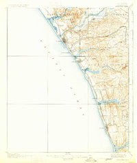
~ Oceanside CA topo map, 1:62500 scale, 15 X 15 Minute, Historical, 1901, updated 1931
Oceanside, California, USGS topographic map dated 1901.
Includes geographic coordinates (latitude and longitude). This topographic map is suitable for hiking, camping, and exploring, or framing it as a wall map.
Printed on-demand using high resolution imagery, on heavy weight and acid free paper, or alternatively on a variety of synthetic materials.
Topos available on paper, Waterproof, Poly, or Tyvek. Usually shipping rolled, unless combined with other folded maps in one order.
- Product Number: USGS-5503327
- Free digital map download (high-resolution, GeoPDF): Oceanside, California (file size: 5 MB)
- Map Size: please refer to the dimensions of the GeoPDF map above
- Weight (paper map): ca. 55 grams
- Map Type: POD USGS Topographic Map
- Map Series: HTMC
- Map Verison: Historical
- Cell ID: 60464
- Scan ID: 298380
- Imprint Year: 1931
- Survey Year: 1898
- Datum: Unstated
- Map Projection: Polyconic
- Map published by United States Geological Survey
- Map Language: English
- Scanner Resolution: 600 dpi
- Map Cell Name: Ocean Side
- Grid size: 15 X 15 Minute
- Date on map: 1901
- Map Scale: 1:62500
- Geographical region: California, United States
Neighboring Maps:
All neighboring USGS topo maps are available for sale online at a variety of scales.
Spatial coverage:
Topo map Oceanside, California, covers the geographical area associated the following places:
- Riviera Mobile Home Park - Park Encinitas Trailer Park - Carlsbad - Lanaki Lane Mobile Home Park - La Costa - Cardiff-by-the-Sea - South Oceanside - Green Valley Mobile Home Park - Oceanside - Oceana - Trico Mobile Estates - Fallbrook Junction - Encinitas - Carlsbad Trailer Park - Laguna Vista Trailer Park - El Camino 76 Trailer Park - Rancho San Luis Rey Trailer Park - The Palms Trailer Park - Tiki Mobile Village - Rancho Carlsbad Trailer Park - Ocean Hills - Mountain View Mobile Estates - Escondido Junction - Farr - Sea Aire Mobile Home Park - Green Valley Mobile Estates - Leucadia - San Luis Rey - Yaldora - Rancho Calevero Mobile Home Park - Talich
- Map Area ID: AREA33.2533-117.5-117.25
- Northwest corner Lat/Long code: USGSNW33.25-117.5
- Northeast corner Lat/Long code: USGSNE33.25-117.25
- Southwest corner Lat/Long code: USGSSW33-117.5
- Southeast corner Lat/Long code: USGSSE33-117.25
- Northern map edge Latitude: 33.25
- Southern map edge Latitude: 33
- Western map edge Longitude: -117.5
- Eastern map edge Longitude: -117.25


