
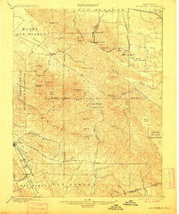
~ Mt Diablo CA topo map, 1:62500 scale, 15 X 15 Minute, Historical, 1898, updated 1905
Mt Diablo, California, USGS topographic map dated 1898.
Includes geographic coordinates (latitude and longitude). This topographic map is suitable for hiking, camping, and exploring, or framing it as a wall map.
Printed on-demand using high resolution imagery, on heavy weight and acid free paper, or alternatively on a variety of synthetic materials.
Topos available on paper, Waterproof, Poly, or Tyvek. Usually shipping rolled, unless combined with other folded maps in one order.
- Product Number: USGS-5503159
- Free digital map download (high-resolution, GeoPDF): Mt Diablo, California (file size: 10 MB)
- Map Size: please refer to the dimensions of the GeoPDF map above
- Weight (paper map): ca. 55 grams
- Map Type: POD USGS Topographic Map
- Map Series: HTMC
- Map Verison: Historical
- Cell ID: 72751
- Scan ID: 298278
- Imprint Year: 1905
- Survey Year: 1896
- Datum: Unstated
- Map Projection: Unstated
- Map published by United States Geological Survey
- Map Language: English
- Scanner Resolution: 600 dpi
- Map Cell Name: Mount Diablo
- Grid size: 15 X 15 Minute
- Date on map: 1898
- Map Scale: 1:62500
- Geographical region: California, United States
Neighboring Maps:
All neighboring USGS topo maps are available for sale online at a variety of scales.
Spatial coverage:
Topo map Mt Diablo, California, covers the geographical area associated the following places:
- Clayton - Alamo Oaks - San Ramon - Newlove - Stewartville - Cowell - Rock City - Neroly - Tassajara - Diablo - Nortonville - Danville - Marsh Creek Springs - Camino Tassajara - Somersville - Blackhawk - West Hartley
- Map Area ID: AREA3837.75-122-121.75
- Northwest corner Lat/Long code: USGSNW38-122
- Northeast corner Lat/Long code: USGSNE38-121.75
- Southwest corner Lat/Long code: USGSSW37.75-122
- Southeast corner Lat/Long code: USGSSE37.75-121.75
- Northern map edge Latitude: 38
- Southern map edge Latitude: 37.75
- Western map edge Longitude: -122
- Eastern map edge Longitude: -121.75


