
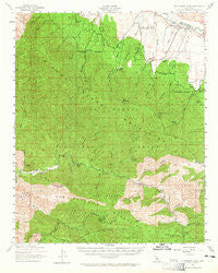
~ McPherson Peak CA topo map, 1:62500 scale, 15 X 15 Minute, Historical, 1941, updated 1965
McPherson Peak, California, USGS topographic map dated 1941.
Includes geographic coordinates (latitude and longitude). This topographic map is suitable for hiking, camping, and exploring, or framing it as a wall map.
Printed on-demand using high resolution imagery, on heavy weight and acid free paper, or alternatively on a variety of synthetic materials.
Topos available on paper, Waterproof, Poly, or Tyvek. Usually shipping rolled, unless combined with other folded maps in one order.
- Product Number: USGS-5502925
- Free digital map download (high-resolution, GeoPDF): McPherson Peak, California (file size: 9 MB)
- Map Size: please refer to the dimensions of the GeoPDF map above
- Weight (paper map): ca. 55 grams
- Map Type: POD USGS Topographic Map
- Map Series: HTMC
- Map Verison: Historical
- Cell ID: 57410
- Scan ID: 298158
- Imprint Year: 1965
- Woodland Tint: Yes
- Aerial Photo Year: 1941
- Datum: NAD27
- Map Projection: Polyconic
- Map published by United States Geological Survey
- Map Language: English
- Scanner Resolution: 600 dpi
- Map Cell Name: McPherson Peak
- Grid size: 15 X 15 Minute
- Date on map: 1941
- Map Scale: 1:62500
- Geographical region: California, United States
Neighboring Maps:
All neighboring USGS topo maps are available for sale online at a variety of scales.
Spatial coverage:
Topo map McPherson Peak, California, covers the geographical area associated the following places:
- Little Spring Canyon - Ernest Blanco Spring - Bates Canyon - Upper Branch Canyon Spring - Big Spring Canyon - Munch Canyon - Aliso Canyon - Davy Brown Creek - Heath Spring - Jackson Trail - Foresters Leap Canyon - Water Canyon - Peak Mountain - Bates Canyon Campground - Sunset Valley - Lonnie Davis Campground - Manzana Trail - Happy Hunting Ground Campground - Painted Rock Campground - Coyote Gulch - Wheat Peak - Upper Trough Canyon Spring - Abel Canyon Campground - South Fork Guard Station - Rines Recreation Site - Hurricane Deck - Cole Spring - Wells Creek - Miller Canyon Campgropund - Mormon Campground - Moon Canyon - Manzana Creek - Fir Canyon - Montgomery Number Two Spring - Green Canyon - Cuyama Division - Docs Spring Campground - East Mine Canyon Spring - Bitter Creek Spring - Hurricane Deck Trail - Sycamore Campground - Sulphur Spring Canyon - Bald Mountain Canyon - Stovall Canyon - Buck Opening Spring - Big Bend Canyon - San Rafael Wilderness - Montgomery Potrero - Hinsdale Ranch - Sweetwater Canyon - Coldwater Campground - Manzana Campground - Fish Creek Campground - Fish Creek - Davy Brown Campground - Deer Spring - Montgomery Number Three Spring - Nira Campground - Oak Canyon - Richardson Spring - Live Oak Spring - Lost Knife Spring - Hidden Spring - South Fork Sisquoc River - Sierra Madre Mountains - Cliff Campground - Eckart Canyon - Hog Pen Spring - McPherson Camp - Big Spring - Caliente Ranch - South Fork Rustic Campsite - White Ledge Canyon - Bates Canyon Campground - Fish Creek Campground - Messenger Canyon - Wellman Canyon - Coldwater Campground - North Mine Canyon Spring - Johnston Spring - Cole Spring Campground - Deadman Canyon - Davis Canyon - Water Canyon Campground - Richardson Canyon - Aliso Campground - Potrero Canyon Trail - Black Willow Spring - Hog Pen Spring Rustic Campsite - Little Spring - Montgomery Spring - Upper Hog Pen Spring - White Oaks Guard Station - McPherson Peak - East Fork Fish Creek - McPherson Campground - Bald Mountain - Miller Canyon - Mine Canyon - Jackson Spring
- Map Area ID: AREA3534.75-120-119.75
- Northwest corner Lat/Long code: USGSNW35-120
- Northeast corner Lat/Long code: USGSNE35-119.75
- Southwest corner Lat/Long code: USGSSW34.75-120
- Southeast corner Lat/Long code: USGSSE34.75-119.75
- Northern map edge Latitude: 35
- Southern map edge Latitude: 34.75
- Western map edge Longitude: -120
- Eastern map edge Longitude: -119.75


