
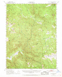
~ Kettle Rock CA topo map, 1:62500 scale, 15 X 15 Minute, Historical, 1950, updated 1968
Kettle Rock, California, USGS topographic map dated 1950.
Includes geographic coordinates (latitude and longitude). This topographic map is suitable for hiking, camping, and exploring, or framing it as a wall map.
Printed on-demand using high resolution imagery, on heavy weight and acid free paper, or alternatively on a variety of synthetic materials.
Topos available on paper, Waterproof, Poly, or Tyvek. Usually shipping rolled, unless combined with other folded maps in one order.
- Product Number: USGS-5502483
- Free digital map download (high-resolution, GeoPDF): Kettle Rock, California (file size: 10 MB)
- Map Size: please refer to the dimensions of the GeoPDF map above
- Weight (paper map): ca. 55 grams
- Map Type: POD USGS Topographic Map
- Map Series: HTMC
- Map Verison: Historical
- Cell ID: 56143
- Scan ID: 297890
- Imprint Year: 1968
- Woodland Tint: Yes
- Aerial Photo Year: 1947
- Field Check Year: 1950
- Datum: NAD27
- Map Projection: Polyconic
- Map published by United States Geological Survey
- Map published by United States Forest Service
- Map Language: English
- Scanner Resolution: 600 dpi
- Map Cell Name: Kettle Rock
- Grid size: 15 X 15 Minute
- Date on map: 1950
- Map Scale: 1:62500
- Geographical region: California, United States
Neighboring Maps:
All neighboring USGS topo maps are available for sale online at a variety of scales.
Spatial coverage:
Topo map Kettle Rock, California, covers the geographical area associated the following places:
- Wildcat Ridge - Hungry Creek - Babcock Peak - Taylor Lake 288 Dam - Poison Creek Spring - Boulder Creek - Taylor Lake - Chipmunk Spring - Flournoy Bridge - Hallett Meadow - Kettle Rock Lake - Lower Lone Rock Valley - Boulder Creek Campground - Antelope Lake - Antelope Valley Dam - Harwood Cabin - Dedication Island - Browns Cabin - Antelope Creek - Lone Pine Mine Number 1 - Mud Lake - Nye Creek - Antelope Valley Reservoir - Lonesome Canyon - Murdock Crossing Spring - Kettle Rock - Cold Stream - Lost Cove Picnic Area - Kessler Peak - Babcock Meadows - Drum Bridge - Big Pine Spring - Engel Mine Upper Camp - Peel Ridge - Thompson Creek - Antelope 1-050 Dam - Ward Creek - Elephants Playground - Meadow Creek - Lucky S Mine - Bootsole Creek - Long Point Campground - Last Chance Creek - Lost Creek - Doctor Smith Flat - Rock Creek - Boulder Creek Work Center - Wilcox Valley - Squaw Valley - Eisenheimer Peak - Morton Creek - Babcock Crossing - Wheeler Peak - Rattlesnake Ravine - Greenville Division - Lone Rock Valley - Oak Flat - Fant Creek - Fant Gathering Corral (historical) - Dry Flat - Squaw Queen Creek - Little Antelope Creek - Clarks Creek - Pioneer Cabin - Davis Creek - Sage Creek - Papoose Peak - Smith Creek - Pierce Creek - Willow Creek - Clearwater Creek - Rattlesnake Peak - Tanners Rock - Beardsley Mine - Lone Rock Campground - Lone Rock - Cinder Spring - Frazier Cabin - Notson Bridge - Cradle Valley - Lights Creek Guard Station (historical) - Rocky Point Spring - Wemple Cabin - Kettle Rock Spring - Section Fifteen Spring - Poison Creek - Lone Rock Creek - Clarks Peak - Antelope Valley - Camp Fourteen - Murdock Crossing - Little Spring - South Branch Ward Creek - Franks Valley - Cool Spring - Green Flat - North Branch Ward Creek - Middle Creek - Long Point - Red Clover Creek
- Map Area ID: AREA40.2540-120.75-120.5
- Northwest corner Lat/Long code: USGSNW40.25-120.75
- Northeast corner Lat/Long code: USGSNE40.25-120.5
- Southwest corner Lat/Long code: USGSSW40-120.75
- Southeast corner Lat/Long code: USGSSE40-120.5
- Northern map edge Latitude: 40.25
- Southern map edge Latitude: 40
- Western map edge Longitude: -120.75
- Eastern map edge Longitude: -120.5


