
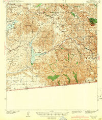
~ Jamul CA topo map, 1:62500 scale, 15 X 15 Minute, Historical, 1943
Jamul, California, USGS topographic map dated 1943.
Includes geographic coordinates (latitude and longitude). This topographic map is suitable for hiking, camping, and exploring, or framing it as a wall map.
Printed on-demand using high resolution imagery, on heavy weight and acid free paper, or alternatively on a variety of synthetic materials.
Topos available on paper, Waterproof, Poly, or Tyvek. Usually shipping rolled, unless combined with other folded maps in one order.
- Product Number: USGS-5502355
- Free digital map download (high-resolution, GeoPDF): Jamul, California (file size: 9 MB)
- Map Size: please refer to the dimensions of the GeoPDF map above
- Weight (paper map): ca. 55 grams
- Map Type: POD USGS Topographic Map
- Map Series: HTMC
- Map Verison: Historical
- Cell ID: 55848
- Scan ID: 297823
- Woodland Tint: Yes
- Survey Year: 1939
- Datum: NAD27
- Map Projection: Polyconic
- Map published by United States Geological Survey
- Map Language: English
- Scanner Resolution: 600 dpi
- Map Cell Name: Jamul
- Grid size: 15 X 15 Minute
- Date on map: 1943
- Map Scale: 1:62500
- Geographical region: California, United States
Neighboring Maps:
All neighboring USGS topo maps are available for sale online at a variety of scales.
Spatial coverage:
Topo map Jamul, California, covers the geographical area associated the following places:
- Indian Springs - Bancroft Point - Casa de Oro - Homelands - Jamacha Junction - Engineer Springs - Cockatoo Grove - Dulzura - North Jamul - Eastlake Greens - Rancho San Diego - Spring Valley - Phelps Corner - Jamacha - Eastlake - Jamul Indian Village - Jamul - Doghouse Junction - La Presa
- Map Area ID: AREA32.7532.5-117-116.75
- Northwest corner Lat/Long code: USGSNW32.75-117
- Northeast corner Lat/Long code: USGSNE32.75-116.75
- Southwest corner Lat/Long code: USGSSW32.5-117
- Southeast corner Lat/Long code: USGSSE32.5-116.75
- Northern map edge Latitude: 32.75
- Southern map edge Latitude: 32.5
- Western map edge Longitude: -117
- Eastern map edge Longitude: -116.75


