
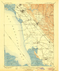
~ Haywards CA topo map, 1:62500 scale, 15 X 15 Minute, Historical, 1899, updated 1906
Haywards, California, USGS topographic map dated 1899.
Includes geographic coordinates (latitude and longitude). This topographic map is suitable for hiking, camping, and exploring, or framing it as a wall map.
Printed on-demand using high resolution imagery, on heavy weight and acid free paper, or alternatively on a variety of synthetic materials.
Topos available on paper, Waterproof, Poly, or Tyvek. Usually shipping rolled, unless combined with other folded maps in one order.
- Product Number: USGS-5502089
- Free digital map download (high-resolution, GeoPDF): Haywards, California (file size: 8 MB)
- Map Size: please refer to the dimensions of the GeoPDF map above
- Weight (paper map): ca. 55 grams
- Map Type: POD USGS Topographic Map
- Map Series: HTMC
- Map Verison: Historical
- Cell ID: 73643
- Scan ID: 297666
- Imprint Year: 1906
- Survey Year: 1896
- Datum: Unstated
- Map Projection: Unstated
- Map published by United States Geological Survey
- Map Language: English
- Scanner Resolution: 600 dpi
- Map Cell Name: Hayward
- Grid size: 15 X 15 Minute
- Date on map: 1899
- Map Scale: 1:62500
- Geographical region: California, United States
Neighboring Maps:
All neighboring USGS topo maps are available for sale online at a variety of scales.
Spatial coverage:
Topo map Haywards, California, covers the geographical area associated the following places:
- Russell City - Jarvis Landing - Lorenzo Station - San Leandro - Mulford Gardens - Hall Station - Mount Eden - Halvern - Ashland - Union City - Fairview - Cherryland - Mowry Landing - Newark - Carpenter - Sorenson - San Lorenzo - Castro Valley - Continental Mobile Home Park - Mattos - Baumberg - Mulford - Pabrico - Redwood Shores - Robert (historical) - Brookfield Village - Hayward - Spanish Ranch Mobile Home Park
- Map Area ID: AREA37.7537.5-122.25-122
- Northwest corner Lat/Long code: USGSNW37.75-122.25
- Northeast corner Lat/Long code: USGSNE37.75-122
- Southwest corner Lat/Long code: USGSSW37.5-122.25
- Southeast corner Lat/Long code: USGSSE37.5-122
- Northern map edge Latitude: 37.75
- Southern map edge Latitude: 37.5
- Western map edge Longitude: -122.25
- Eastern map edge Longitude: -122


