
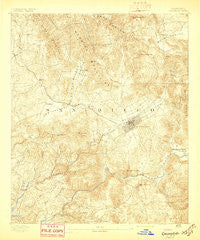
~ Escondido CA topo map, 1:62500 scale, 15 X 15 Minute, Historical, 1893, updated 1897
Escondido, California, USGS topographic map dated 1893.
Includes geographic coordinates (latitude and longitude). This topographic map is suitable for hiking, camping, and exploring, or framing it as a wall map.
Printed on-demand using high resolution imagery, on heavy weight and acid free paper, or alternatively on a variety of synthetic materials.
Topos available on paper, Waterproof, Poly, or Tyvek. Usually shipping rolled, unless combined with other folded maps in one order.
- Product Number: USGS-5501665
- Free digital map download (high-resolution, GeoPDF): Escondido, California (file size: 9 MB)
- Map Size: please refer to the dimensions of the GeoPDF map above
- Weight (paper map): ca. 55 grams
- Map Type: POD USGS Topographic Map
- Map Series: HTMC
- Map Verison: Historical
- Cell ID: 53951
- Scan ID: 297424
- Imprint Year: 1897
- Survey Year: 1891
- Datum: Unstated
- Map Projection: Unstated
- Map published by United States Geological Survey
- Map Language: English
- Scanner Resolution: 600 dpi
- Map Cell Name: Escondido
- Grid size: 15 X 15 Minute
- Date on map: 1893
- Map Scale: 1:62500
- Geographical region: California, United States
Neighboring Maps:
All neighboring USGS topo maps are available for sale online at a variety of scales.
Spatial coverage:
Topo map Escondido, California, covers the geographical area associated the following places:
- Lake Bernardo Estates Mobile Home Park - Richland - Harmony Grove - Hidden Meadows - Ponderosa Club Mobile Home Park - Jesmond Dene - Buena - Escondido Terrace Mobile Home Park - Carefree Ranch Mobile Home Park - Bellview Park Mobile Home Park - Olivenhain - Escondido - Westwinds Lodge Mobile Home Park - LaMoree Mobile Estates - Green Tree Estates Mobile Home Park - Hideaway Mobile Estates - Casa de Amigos Mobile Home Park - Lake San Marcos - Rancho Escondido Mobile Home Park - Green Valley - Imperial Escondido Estates Mobile Home Park - Palomar Park Mobile Home Park - Mobile Park West Mobile Home Park - Villa Madeira Mobile Home Park - Foothills of San Marcos Mobile Home Park - Twin Oaks - Mobile Haven Mobile Home Park - Sundance Mobile Home Park - Casa Grande Estates Mobile Home Park - Casitas del Sol Mobile Home Park - Palomar West Mobile Home Park - Greencrest Park Mobile Home Park - Rancho Vista Mobile Home Park - Citrus Gardens Mobile Home Park - Friendly Hills Manor Mobile Home Park - Hidden Vale Mobile Home Park - Gold Star Mobile Home - Canyon Crest Mobile Home Park - Sierra Vista Trailer Park - Palomar East Mobile Home Park - Vista Manor Trailer Park - Ivy del Mobile Home Park - Del Dios - Moonglow Mobile Home Park - Sunset Terrace Mobile Home Park - Rancho Santa Fe - Vista - Sycamore Creek Mobile Home Park - Madrid Manor Mobile Home Park - Vista Cascade Mobile Home Park - San Marcos - San Marcos Mobile Estates - The Views Mobile Home Park - Rancho Bernardo - Lawrence Welk Resort Village - Vista Verde Estates Mobile Home Park - Valley Center - Elfin Forest - Town and Country Mobile Home Park
- Map Area ID: AREA33.2533-117.25-117
- Northwest corner Lat/Long code: USGSNW33.25-117.25
- Northeast corner Lat/Long code: USGSNE33.25-117
- Southwest corner Lat/Long code: USGSSW33-117.25
- Southeast corner Lat/Long code: USGSSE33-117
- Northern map edge Latitude: 33.25
- Southern map edge Latitude: 33
- Western map edge Longitude: -117.25
- Eastern map edge Longitude: -117


