
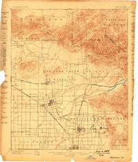
~ Anaheim CA topo map, 1:62500 scale, 15 X 15 Minute, Historical, 1898, updated 1899
Anaheim, California, USGS topographic map dated 1898.
Includes geographic coordinates (latitude and longitude). This topographic map is suitable for hiking, camping, and exploring, or framing it as a wall map.
Printed on-demand using high resolution imagery, on heavy weight and acid free paper, or alternatively on a variety of synthetic materials.
Topos available on paper, Waterproof, Poly, or Tyvek. Usually shipping rolled, unless combined with other folded maps in one order.
- Product Number: USGS-5500357
- Free digital map download (high-resolution, GeoPDF): Anaheim, California (file size: 7 MB)
- Map Size: please refer to the dimensions of the GeoPDF map above
- Weight (paper map): ca. 55 grams
- Map Type: POD USGS Topographic Map
- Map Series: HTMC
- Map Verison: Historical
- Cell ID: 50539
- Scan ID: 296693
- Imprint Year: 1899
- Survey Year: 1894
- Datum: Unstated
- Map Projection: Unstated
- Map published by United States Geological Survey
- Map Language: English
- Scanner Resolution: 600 dpi
- Map Cell Name: Anaheim
- Grid size: 15 X 15 Minute
- Date on map: 1898
- Map Scale: 1:62500
- Geographical region: California, United States
Neighboring Maps:
All neighboring USGS topo maps are available for sale online at a variety of scales.
Spatial coverage:
Topo map Anaheim, California, covers the geographical area associated the following places:
- Wanda (historical) - Olinda (historical) - Bahia Trailer Villa - Katella Mobile Home Estates - Summerset Mobile Home Estates - McPherson - Los Alamitos Junction - Orange Village Mobile Home Park - West Anaheim - Chino Hills - Casa Hermosa Mobile Home Park - Orange - Placentia - Del Ray Mobile Home Estates - Stanton - Fuller Park - Meadowlark Mobile Home Estates - Fullerton - Anaheim Shores - Americana Mobile Home Park - Fernwood Mobile Home Park - Oleo (historical) - El Modena - Nutwood - Palm Lodge Mobile Home Estates - La Habra Heights - Willowick Royal Mobile Home Park - Rancho Fullerton Mobile Home Estates - West Grove Mobile Home Estates - Ocean Breeze Trailer Park - Golden Skies Mobile Home Park - South Grove Mobile Home Estates - West Anaheim Junction - La Belle Fontane Estates - Goldcrest Mobile Home Club - Westminster Mobile Home Park - Neff - Del Cerro Mobile Home Estates - Parque Pacifico Mobile Home Park - Peralta Hills - South Anaheim - Orange Park Acres - Emerald Isle Mobile Home Park - Otterbein - Rowland Heights - Santa Ysabel (historical) - Brookhurst - Northam (historical) - Daum (historical) - Green Lantern Village - East La Mirada - Lemon Heights - Berrydale Trailer Park - Rancho Thirty-nine Mobile Home Park - Villa Capri Mobile Home Park - Del Prado Mobile Park Club - Eldorado Mobile Home Estates - Brea Chem - Villa Park - Leffingwell - Yorba Linda - Cowan Heights - Yorba - Sunny Hills - Orangetree - Friendly Village of Anaheim - Rancho La Paz - Micaflores - Brea - Cerro Villa Heights - Esperanza - Carriage Mobile Home Estates - Clair - Marlboro - Miraflores (historical) - Beach West Mobile Home Estates - Atwood - Plantation Mobile Home Estates - Richfields - Des Moines - Goforth Mobile Home Village - Rio Vista Mobile Home Estates - Tree Mobile Home Park - Hacienda Heights - Anaheim Hills - Oasis Mobile Home Park - Colonia Manzanilla - Anaheim Mobile Home Estates - Sahara Mobile Home Park - Hacienda Mobile Home Park - Hewes Park - La Paloma - Olive - Garden Grove - Almond - North Tustin - Carlton - Creekside Mobile Home Estates - Anaheim Royal Mobile Home Park - Ponderosa Mobile Home Estates
- Map Area ID: AREA3433.75-118-117.75
- Northwest corner Lat/Long code: USGSNW34-118
- Northeast corner Lat/Long code: USGSNE34-117.75
- Southwest corner Lat/Long code: USGSSW33.75-118
- Southeast corner Lat/Long code: USGSSE33.75-117.75
- Northern map edge Latitude: 34
- Southern map edge Latitude: 33.75
- Western map edge Longitude: -118
- Eastern map edge Longitude: -117.75


