
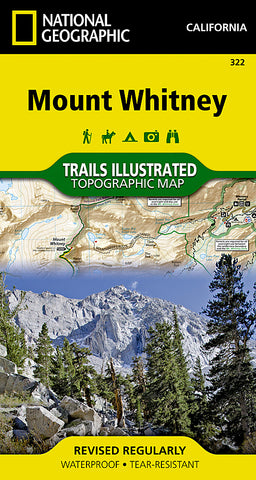


Mount Whitney by National Geographic Maps
Mount Whitney is universally famous as the highest mountain in the United State outside of Alaska, as well as the highest point in California. National Geographics Trails Illustrated map of Mount Whitney is a two-sided, waterproof map designed to meet the needs of Whitney visitors with unmatched durability, detail, and up-to-date recreation information.
The front side of the map details the topography, hiking and horse trails of Mount Whitneys south side, through Sequoia National Park, Inyo National Forest and Golden Trout Wilderness. The Pacific Crest Trail cuts a treasured pathway through the map, with clearly illustrated amenities available at Cottonwood Pass and Cottonwood Lakes campgrounds just a short hike away. The inset features tips on backcountry safety, contact numbers, and essential information about the region.
The north side topography on the reverse side treks through Sequoia National Park, Sequoia-Kings Canyon Wilderness, Inyo National Park, and the John Muir Wilderness. Both the Pacific Crest and John Muir Trails are highlighted, along with the complete and most popular route for ascending the mountain, the 11-mile Mount Whitney Trail (alternate routes are also shown). View the amenities of the Lone Pine, Tuttle Creek, and Whitney Portal campgrounds, where hikers begin to acclimate. An inset illustrates the elevation of the Mount Whitney trail profile to its 14,494 foot summit.
- Product Number: 2128315M
- Product Code: TI_WHITNEY
- Publisher Product ID: TI00000322
- ISBN: 9781566956468
- Year of Publication: 2013
- Folded Size: 7.48 x 4.33 inches
- Unfolded Size: 21.26 x 31.5 inches
- Map type: Folded Map
- Geographical region: California


