
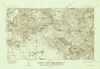
~ Cave Creek AZ topo map, 1:96000 scale, 30 X 30 Minute, Historical, 1930
Cave Creek, Arizona, USGS topographic map dated 1930.
Includes geographic coordinates (latitude and longitude). This topographic map is suitable for hiking, camping, and exploring, or framing it as a wall map.
Printed on-demand using high resolution imagery, on heavy weight and acid free paper, or alternatively on a variety of synthetic materials.
Topos available on paper, Waterproof, Poly, or Tyvek. Usually shipping rolled, unless combined with other folded maps in one order.
- Product Number: USGS-5680187
- Free digital map download (high-resolution, GeoPDF): Cave Creek, Arizona (file size: 9 MB)
- Map Size: please refer to the dimensions of the GeoPDF map above
- Weight (paper map): ca. 55 grams
- Map Type: POD USGS Topographic Map
- Map Series: HTMC
- Map Verison: Historical
- Cell ID: 65160
- Scan ID: 315224
- Survey Year: 1930
- Datum: NAD
- Map Projection: Polyconic
- Advance: Yes
- Map published by United States Geological Survey
- Keywords: Overedge
- Map Language: English
- Scanner Resolution: 600 dpi
- Map Cell Name: Cave Creek
- Grid size: 30 X 30 Minute
- Date on map: 1930
- Map Scale: 1:96000
- Geographical region: Arizona, United States
Neighboring Maps:
All neighboring USGS topo maps are available for sale online at a variety of scales.
Spatial coverage:
Topo map Cave Creek, Arizona, covers the geographical area associated the following places:
- Hyde Park - Pinnacle Peak Country Club Estates - Sweetwater Ranch - Paradise Peak West Mobile Home Park - Cobblestone Square - Gainey Ranch - Fountain Hills - Happy Valley Ranch - Country Trace - Dixileta Verde - Sandalwood - Carefree - Carefree Foothills - Greenway Park V - Clearview Hills - Ensenada del Oro - Fort McDowell - Las Villas - Heritage Terrace - Taliesin West - Cinco Soles - Mirador - Santiago - Doubletree Canyon - Pinnacle Peak Heights IV - Sun Valley Mobile Home Park - Scottsdale - Woodleaf - Desert Wind - The Covey - Village Fairways - Windemere - Quail Valley - Andalusia - Rio Verde - Chimney Hill - Paradise Valley - Heritage Court - Casa Rica - Pinnacle Peak Heights V-VI - Paradise Village North II - Shiloh Canyon - Kensington - Woodleaf II - Rio Verde Estates - Pinnacle Paradise - Estados de La Mancha II - Tonto Hills Subdivision - Camp Creek - Scottsdale Ranch - Camelback Estates IV - Cave Creek - Reata Pass - Pinnacle Peak Village - Pinnacle Peak Estates II - Montclair Terrace - Preston Hills - Desert Ridge - Vista del Cerro - Windsong - Mission Monterey - Desert Highlands - Greenbrier East - Heritage North Ranch - Pinnacle Peak Estates III - Links Point - Buenavante - Haciendas del Lago - Orangetree Estates - Pinnacle Peak Shadows - Cactus Villa - Pinnacle Peak Estates I - Lone Mountain Ranch - El Paseo - Desert Highlands - Troon - Continental Village - Rancho Santa Fe - Dove Valley Ranch - Desert Wind II - Fountain View - DC Ranch - McDowell Mountain Ranch - Santo Tomas - Bell Acres Mobile Home Park - McCormick Ranch - Trovia - Currys Corner - Oakhurst - Firebrand Ranch - Country Horizons - Paradise Valley Miranda - Basking Ridge - Sunset Ridge I - Sincuidados - Pinnacle Peak Heights - Sweetwater Garden - Shadow Ridge II
- Map Area ID: AREA3433.5-112-111.5
- Northwest corner Lat/Long code: USGSNW34-112
- Northeast corner Lat/Long code: USGSNE34-111.5
- Southwest corner Lat/Long code: USGSSW33.5-112
- Southeast corner Lat/Long code: USGSSE33.5-111.5
- Northern map edge Latitude: 34
- Southern map edge Latitude: 33.5
- Western map edge Longitude: -112
- Eastern map edge Longitude: -111.5


