
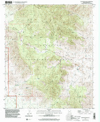
~ Stockton Pass AZ topo map, 1:24000 scale, 7.5 X 7.5 Minute, Historical, 1996, updated 2002
Stockton Pass, Arizona, USGS topographic map dated 1996.
Includes geographic coordinates (latitude and longitude). This topographic map is suitable for hiking, camping, and exploring, or framing it as a wall map.
Printed on-demand using high resolution imagery, on heavy weight and acid free paper, or alternatively on a variety of synthetic materials.
Topos available on paper, Waterproof, Poly, or Tyvek. Usually shipping rolled, unless combined with other folded maps in one order.
- Product Number: USGS-5556254
- Free digital map download (high-resolution, GeoPDF): Stockton Pass, Arizona (file size: 15 MB)
- Map Size: please refer to the dimensions of the GeoPDF map above
- Weight (paper map): ca. 55 grams
- Map Type: POD USGS Topographic Map
- Map Series: HTMC
- Map Verison: Historical
- Cell ID: 71728
- Scan ID: 313558
- Imprint Year: 2002
- Woodland Tint: Yes
- Aerial Photo Year: 1996
- Datum: NAD83
- Map Projection: Universal Transverse Mercator
- Map published by United States Geological Survey
- Map Language: English
- Scanner Resolution: 600 dpi
- Map Cell Name: Stockton Pass
- Grid size: 7.5 X 7.5 Minute
- Date on map: 1996
- Map Scale: 1:24000
- Geographical region: Arizona, United States
Neighboring Maps:
All neighboring USGS topo maps are available for sale online at a variety of scales.
Spatial coverage:
Topo map Stockton Pass, Arizona, covers the geographical area associated the following places:
- Ladybug Peak - Alder Spring - Hog Canyon - Cove Canyon - Bar X Canyon - Trap Spring - C N Seep - O Bar O Tank - Martin Canyon - Gillespie Wash - Jernigan Trick Tank - Bar X Tank - Hog Canyon Tank - Bear Canyon - Mash Barrel Spring - Stockton Pass Campground - Little Cottonwood Canyon - Jernigan Ranch - Half Moon Spring - Bear Canyon Two hundred ninety-nine Trail - C N Wash - Gillespie Well - Hog Spring - Bootlegger Spring - Rock Spring - Kane Spring - Bar X Trick Tank - Hidden Spring - Righthand Spring - Cove Spring - Dutch Henry Two hundred ninety seven Trail - Kane Spring Mountain - Stockton Pass - C N Ranch - Gillespie (historical) - Maverick Mountain - Corner Tank - Shake Spring - Ladybug Saddle - Righthand Dam
- Map Area ID: AREA32.62532.5-109.875-109.75
- Northwest corner Lat/Long code: USGSNW32.625-109.875
- Northeast corner Lat/Long code: USGSNE32.625-109.75
- Southwest corner Lat/Long code: USGSSW32.5-109.875
- Southeast corner Lat/Long code: USGSSE32.5-109.75
- Northern map edge Latitude: 32.625
- Southern map edge Latitude: 32.5
- Western map edge Longitude: -109.875
- Eastern map edge Longitude: -109.75


