
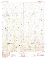
~ Shingle Mill Mountain AZ topo map, 1:24000 scale, 7.5 X 7.5 Minute, Historical, 1985, updated 1986
Shingle Mill Mountain, Arizona, USGS topographic map dated 1985.
Includes geographic coordinates (latitude and longitude). This topographic map is suitable for hiking, camping, and exploring, or framing it as a wall map.
Printed on-demand using high resolution imagery, on heavy weight and acid free paper, or alternatively on a variety of synthetic materials.
Topos available on paper, Waterproof, Poly, or Tyvek. Usually shipping rolled, unless combined with other folded maps in one order.
- Product Number: USGS-5555822
- Free digital map download (high-resolution, GeoPDF): Shingle Mill Mountain, Arizona (file size: 10 MB)
- Map Size: please refer to the dimensions of the GeoPDF map above
- Weight (paper map): ca. 55 grams
- Map Type: POD USGS Topographic Map
- Map Series: HTMC
- Map Verison: Historical
- Cell ID: 41099
- Scan ID: 313347
- Imprint Year: 1986
- Woodland Tint: Yes
- Aerial Photo Year: 1981
- Edit Year: 1985
- Field Check Year: 1983
- Datum: NAD27
- Map Projection: Transverse Mercator
- Provisional map: Yes
- Map published by United States Geological Survey
- Map Language: English
- Scanner Resolution: 600 dpi
- Map Cell Name: Shingle Mill Mountain
- Grid size: 7.5 X 7.5 Minute
- Date on map: 1985
- Map Scale: 1:24000
- Geographical region: Arizona, United States
Neighboring Maps:
All neighboring USGS topo maps are available for sale online at a variety of scales.
Spatial coverage:
Topo map Shingle Mill Mountain, Arizona, covers the geographical area associated the following places:
- Shingle Mill Mountain - Coyote Tank - Lamb Hotel - Dickey Spring - Merrill Wash - Mexican Canyon - Shingle Mill Canyon - Carter Canyon Number Thirty four Trail - Mexican Tank - North Taylor Canyon - Green Spring - Lamb Tank - Hells Hole Creek - Seven Cross Tank - Nuttall Canyon - Bear Springs Knoll - Stockpond Tank - Blair Canyon - Carter Canyon - Lefthand Canyon - Wide Mouth Canyon - Stowe Knoll - Tunnel Canyon - Squaw Tank - Cottonwood Creek - Sand Tank - Bear Basin - Webb One Tank - Hulda Gap Corral - Bear Springs - Bigler Ponds - Bryce Knoll - Flying J Ranch Airport - Coyote Knoll - Shingle Mill Mesa Thirty Five Trail - Goat Hill - Pima Well - Sand Wash - Chatfield Pond - Carter Tank - Bear Springs Wash - Tramline Tank - Browns Tank - Dead Steer Mesa - Ringcone Tank - Hells Hole Canyon - Middle Wash
- Map Area ID: AREA32.87532.75-110-109.875
- Northwest corner Lat/Long code: USGSNW32.875-110
- Northeast corner Lat/Long code: USGSNE32.875-109.875
- Southwest corner Lat/Long code: USGSSW32.75-110
- Southeast corner Lat/Long code: USGSSE32.75-109.875
- Northern map edge Latitude: 32.875
- Southern map edge Latitude: 32.75
- Western map edge Longitude: -110
- Eastern map edge Longitude: -109.875


