
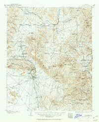
~ Congress AZ topo map, 1:125000 scale, 30 X 30 Minute, Historical, 1903, updated 1962
Congress, Arizona, USGS topographic map dated 1903.
Includes geographic coordinates (latitude and longitude). This topographic map is suitable for hiking, camping, and exploring, or framing it as a wall map.
Printed on-demand using high resolution imagery, on heavy weight and acid free paper, or alternatively on a variety of synthetic materials.
Topos available on paper, Waterproof, Poly, or Tyvek. Usually shipping rolled, unless combined with other folded maps in one order.
- Product Number: USGS-5549336
- Free digital map download (high-resolution, GeoPDF): Congress, Arizona (file size: 9 MB)
- Map Size: please refer to the dimensions of the GeoPDF map above
- Weight (paper map): ca. 55 grams
- Map Type: POD USGS Topographic Map
- Map Series: HTMC
- Map Verison: Historical
- Cell ID: 65262
- Scan ID: 315351
- Imprint Year: 1962
- Survey Year: 1903
- Datum: Unstated
- Map Projection: Polyconic
- Map published by United States Geological Survey
- Map Language: English
- Scanner Resolution: 600 dpi
- Map Cell Name: Congress
- Grid size: 30 X 30 Minute
- Date on map: 1903
- Map Scale: 1:125000
- Geographical region: Arizona, United States
Neighboring Maps:
All neighboring USGS topo maps are available for sale online at a variety of scales.
Spatial coverage:
Topo map Congress, Arizona, covers the geographical area associated the following places:
- Hillside - Stanton - Yarnell - Peeples Valley - Rush Place Windmill - Sand Mill - Walker Place Windmill - Constellation - Ferguson Place Windmill - Date - Walnut Grove - Wagoner - Glen Oaks - Piedmont - Congress Junction - Hawkins - Congress - Kirkland - Flores - Grand View - Glen Ilah - Yava - Octave - Wilhoit - Kirkland Junction
- Map Area ID: AREA34.534-113-112.5
- Northwest corner Lat/Long code: USGSNW34.5-113
- Northeast corner Lat/Long code: USGSNE34.5-112.5
- Southwest corner Lat/Long code: USGSSW34-113
- Southeast corner Lat/Long code: USGSSE34-112.5
- Northern map edge Latitude: 34.5
- Southern map edge Latitude: 34
- Western map edge Longitude: -113
- Eastern map edge Longitude: -112.5


