
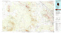
~ Silver Bell Mountains AZ topo map, 1:100000 scale, 30 X 60 Minute, Historical, 1994, updated 1994
Silver Bell Mountains, Arizona, USGS topographic map dated 1994.
Includes geographic coordinates (latitude and longitude). This topographic map is suitable for hiking, camping, and exploring, or framing it as a wall map.
Printed on-demand using high resolution imagery, on heavy weight and acid free paper, or alternatively on a variety of synthetic materials.
Topos available on paper, Waterproof, Poly, or Tyvek. Usually shipping rolled, unless combined with other folded maps in one order.
- Product Number: USGS-5549242
- Free digital map download (high-resolution, GeoPDF): Silver Bell Mountains, Arizona (file size: 25 MB)
- Map Size: please refer to the dimensions of the GeoPDF map above
- Weight (paper map): ca. 55 grams
- Map Type: POD USGS Topographic Map
- Map Series: HTMC
- Map Verison: Historical
- Cell ID: 68367
- Scan ID: 315307
- Imprint Year: 1994
- Woodland Tint: Yes
- Aerial Photo Year: 1992
- Edit Year: 1994
- Datum: NAD27
- Map Projection: Universal Transverse Mercator
- Map published by United States Geological Survey
- Map Language: English
- Scanner Resolution: 600 dpi
- Map Cell Name: Silver Bell Mountains
- Grid size: 30 X 60 Minute
- Date on map: 1994
- Map Scale: 1:100000
- Geographical region: Arizona, United States
Neighboring Maps:
All neighboring USGS topo maps are available for sale online at a variety of scales.
Spatial coverage:
Topo map Silver Bell Mountains, Arizona, covers the geographical area associated the following places:
- Haivana Nakya - Drexel Heights - Pipyak - Green Acres Mobile Home Park - Continental West Mobile Home Park - Sil Nakya - Shannon Trees Mobile Home Park - Noblesse Oblige Mobile Home Estates - Gardner Estates - North Star Mobile Home Community - Queens Well - Orange Grove Estates - Double R Ranch Mobile Home Park - Valle Vista Mobile Home Park - Rancho El Sol Mobile Home Park - Nawt Vaya - La Colonia Mobile Home Park - San Pedro - Nelson - Comobabi - San Luis - Jaynes - Desert Sun Desert Winds Mobile Home Park - Acacia Gardens Mobile Home Park - Branding Iron Mobile Home Park - Old Tucson Estates - Tucson National Estates - Three Points - Marana - Adonis Mobile Home Subdivision - Cortaro - Orange Grove Mobile Estates - Ko Vaya - Silver Cholla Mobile Park - Hoi Oidak - Picture Rocks - Gardner Mobile Home Estates - Old Tucson - Valley of the Sun Mobile Home Park - Pan Tak - Shady Lanes Mobile Home Park - Silverbell - Silent Wheels Ranchomes - Dobson - Cactus Garden Mobile Home Park - Black Mountain Estates - Naviska - Vista Del Rey Mobile Home Park - Tortolita - Rincon - Flowing Wells - Nolic - Wickchoupai - Villa Capri Mobile Home Park Phase I - Kino - Arizonian Mobile Home Park - Avra - Rillito - Cactus Cove Mobile Home Park - Stockham - Carefree Village Mobile Home Park - Mountainside Village Mobile Home Park - Santa Lucia - Quinlin - Tucson Estates - Romero Trailer Estates - Skoksonak - Silver Bell - Robles Junction - Diamond Grove Estates Mobile Home Park - Cardinal Lane Mobile Home Park - Avra Valley - Corner Windmill - Makgum Havoka - Santa Cruz - Palm Vista Estates Mobile Home Park - Hinsons Mobile Home Park - Schuchk - San Vicente - Park West Mobile Homes Estates - Golden Park for Mobile Homes - Falcon Ridge Mobile Home Park
- Map Area ID: AREA32.532-112-111
- Northwest corner Lat/Long code: USGSNW32.5-112
- Northeast corner Lat/Long code: USGSNE32.5-111
- Southwest corner Lat/Long code: USGSSW32-112
- Southeast corner Lat/Long code: USGSSE32-111
- Northern map edge Latitude: 32.5
- Southern map edge Latitude: 32
- Western map edge Longitude: -112
- Eastern map edge Longitude: -111


