
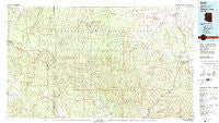
~ Show Low AZ topo map, 1:100000 scale, 30 X 60 Minute, Historical, 1981, updated 1982
Show Low, Arizona, USGS topographic map dated 1981.
Includes geographic coordinates (latitude and longitude). This topographic map is suitable for hiking, camping, and exploring, or framing it as a wall map.
Printed on-demand using high resolution imagery, on heavy weight and acid free paper, or alternatively on a variety of synthetic materials.
Topos available on paper, Waterproof, Poly, or Tyvek. Usually shipping rolled, unless combined with other folded maps in one order.
- Product Number: USGS-5549238
- Free digital map download (high-resolution, GeoPDF): Show Low, Arizona (file size: 28 MB)
- Map Size: please refer to the dimensions of the GeoPDF map above
- Weight (paper map): ca. 55 grams
- Map Type: POD USGS Topographic Map
- Map Series: HTMC
- Map Verison: Historical
- Cell ID: 72196
- Scan ID: 315305
- Imprint Year: 1982
- Woodland Tint: Yes
- Visual Version Number: 2
- Aerial Photo Year: 1978
- Edit Year: 1981
- Datum: NAD27
- Map Projection: Universal Transverse Mercator
- Map published by United States Geological Survey
- Map Language: English
- Scanner Resolution: 600 dpi
- Map Cell Name: Show Low
- Grid size: 30 X 60 Minute
- Date on map: 1981
- Map Scale: 1:100000
- Geographical region: Arizona, United States
Neighboring Maps:
All neighboring USGS topo maps are available for sale online at a variety of scales.
Spatial coverage:
Topo map Show Low, Arizona, covers the geographical area associated the following places:
- Timberline Mobile Home Community - Burton - Roundy Crossing - Aripine - Heber - Taylor - Ponderosa Spring Subdivision - Forest Lakes Estates - Schoens Crossing - Cibecue - Grasshopper - Young - Overgaard - Venture In Resort Mobile Home Park - Colcord Mountain Estates - Pine Shadows Mobile Home Park - Shumway - Show Low - Robinson Trail Crossing - Pinedale - Linden - Cibecue Creek - Clay Springs - Sleepy Hollow - Camptown Mobile Home Park - Paradise Trailer Park
- Map Area ID: AREA34.534-111-110
- Northwest corner Lat/Long code: USGSNW34.5-111
- Northeast corner Lat/Long code: USGSNE34.5-110
- Southwest corner Lat/Long code: USGSSW34-111
- Southeast corner Lat/Long code: USGSSE34-110
- Northern map edge Latitude: 34.5
- Southern map edge Latitude: 34
- Western map edge Longitude: -111
- Eastern map edge Longitude: -110


