
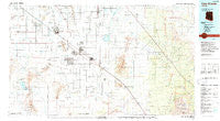
~ Casa Grande AZ topo map, 1:100000 scale, 30 X 60 Minute, Historical, 1994, updated 1994
Casa Grande, Arizona, USGS topographic map dated 1994.
Includes geographic coordinates (latitude and longitude). This topographic map is suitable for hiking, camping, and exploring, or framing it as a wall map.
Printed on-demand using high resolution imagery, on heavy weight and acid free paper, or alternatively on a variety of synthetic materials.
Topos available on paper, Waterproof, Poly, or Tyvek. Usually shipping rolled, unless combined with other folded maps in one order.
- Product Number: USGS-5549086
- Free digital map download (high-resolution, GeoPDF): Casa Grande, Arizona (file size: 21 MB)
- Map Size: please refer to the dimensions of the GeoPDF map above
- Weight (paper map): ca. 55 grams
- Map Type: POD USGS Topographic Map
- Map Series: HTMC
- Map Verison: Historical
- Cell ID: 67249
- Scan ID: 315237
- Imprint Year: 1994
- Woodland Tint: Yes
- Aerial Photo Year: 1992
- Edit Year: 1994
- Datum: NAD27
- Map Projection: Universal Transverse Mercator
- Map published by United States Geological Survey
- Map Language: English
- Scanner Resolution: 600 dpi
- Map Cell Name: Casa Grande
- Grid size: 30 X 60 Minute
- Date on map: 1994
- Map Scale: 1:100000
- Geographical region: Arizona, United States
Neighboring Maps:
All neighboring USGS topo maps are available for sale online at a variety of scales.
Spatial coverage:
Topo map Casa Grande, Arizona, covers the geographical area associated the following places:
- Shopishk - La Palma - La Posada Trailer Park - Toltec - Nariska - Wymola - Arizola - Avra - Borree Corner - Colonial Del Sol Mobile Home Park - Jackrabbit House - Coolidge - Randolph - Foothills West Resort Mobile Home Park - Eleven Mile Corner - Fiesta Grande Mobile Home Park - Cottonwood Cove Mobile Home Park - Roadrunner Mobile Home Park - Red Rock - Valley Farms - Bon - Chuichu - Sunny Lane Mobile Home Park - Picacho - Arizona City - Laguna - Vaiva Vo - Casa Grande - Tat Momoli - Sunwest Resort Mobile Home Park - Friendly Corners - Stanfield - Safari Mobile Home Park - Rodeo Estates Mobile Home Park - Casa Verde Estates Mobile Home Park - Cactus Forest - Las Casitas Mobile Home Park - Casa Grande East Mobile Home Park - North Komelik - Eloy
- Map Area ID: AREA3332.5-112-111
- Northwest corner Lat/Long code: USGSNW33-112
- Northeast corner Lat/Long code: USGSNE33-111
- Southwest corner Lat/Long code: USGSSW32.5-112
- Southeast corner Lat/Long code: USGSSE32.5-111
- Northern map edge Latitude: 33
- Southern map edge Latitude: 32.5
- Western map edge Longitude: -112
- Eastern map edge Longitude: -111


