
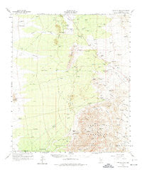
~ Tortolita Mts AZ topo map, 1:62500 scale, 15 X 15 Minute, Historical, 1959, updated 1974
Tortolita Mts, Arizona, USGS topographic map dated 1959.
Includes geographic coordinates (latitude and longitude). This topographic map is suitable for hiking, camping, and exploring, or framing it as a wall map.
Printed on-demand using high resolution imagery, on heavy weight and acid free paper, or alternatively on a variety of synthetic materials.
Topos available on paper, Waterproof, Poly, or Tyvek. Usually shipping rolled, unless combined with other folded maps in one order.
- Product Number: USGS-5548856
- Free digital map download (high-resolution, GeoPDF): Tortolita Mts, Arizona (file size: 8 MB)
- Map Size: please refer to the dimensions of the GeoPDF map above
- Weight (paper map): ca. 55 grams
- Map Type: POD USGS Topographic Map
- Map Series: HTMC
- Map Verison: Historical
- Cell ID: 63641
- Scan ID: 315114
- Imprint Year: 1974
- Woodland Tint: Yes
- Aerial Photo Year: 1958
- Field Check Year: 1959
- Datum: NAD27
- Map Projection: Polyconic
- Map published by United States Geological Survey
- Map published by United States Army Corps of Engineers
- Map Language: English
- Scanner Resolution: 600 dpi
- Map Cell Name: Tortolita Mountains
- Grid size: 15 X 15 Minute
- Date on map: 1959
- Map Scale: 1:62500
- Geographical region: Arizona, United States
Neighboring Maps:
All neighboring USGS topo maps are available for sale online at a variety of scales.
Spatial coverage:
Topo map Tortolita Mts, Arizona, covers the geographical area associated the following places:
- Barriles Ranch - Blue Ribbon Tank - Hit Tank - Big Tank - Miller Wash - Ogle Well - Forman Wash - Gas Line Tank - Fresnal Canyon - Lopez Wells - Slash Well - Cross Triangle Ranch - Sampson Well - South Tank - Guild Wash - Tipperary Wash - Goodman Ranch - Suizo Mountains - Twin Hawks Airpark - Mesa Tank - North Well - Black Tank - Carpenter Ranch - Forman Ranch - Big Mine - Suizo Well - Magma Well - Sutton Well - Palo Verde Ranch - Dry Canyon - Cadillac Tank - Freeman Tank - Big Mine - Antelope Peak - Bass Canyon - Eberhardt Ranch - Owl Head Buttes - Suffering Wash - Bass Spring - Panther Butte - Mine Well - McKenzie Ranch - Cochie Spring - Green Tank - Power Line Wash - Olsen Wash - Durham Hills - Copper Mine Tank - Jeffords Peak - The Huerfano - Desert Peak - Cottonwood Canyon - Crow Wash - Riddle Windmill - Chief Butte - Crow Windmill - Derrio Canyon - Davis Ranch - Three Buttes - Cottonwood Spring - Parker Canyon
- Map Area ID: AREA32.7532.5-111.25-111
- Northwest corner Lat/Long code: USGSNW32.75-111.25
- Northeast corner Lat/Long code: USGSNE32.75-111
- Southwest corner Lat/Long code: USGSSW32.5-111.25
- Southeast corner Lat/Long code: USGSSE32.5-111
- Northern map edge Latitude: 32.75
- Southern map edge Latitude: 32.5
- Western map edge Longitude: -111.25
- Eastern map edge Longitude: -111


