
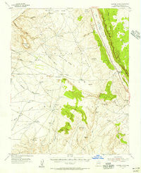
~ Shinumo Altar AZ topo map, 1:62500 scale, 15 X 15 Minute, Historical, 1954, updated 1956
Shinumo Altar, Arizona, USGS topographic map dated 1954.
Includes geographic coordinates (latitude and longitude). This topographic map is suitable for hiking, camping, and exploring, or framing it as a wall map.
Printed on-demand using high resolution imagery, on heavy weight and acid free paper, or alternatively on a variety of synthetic materials.
Topos available on paper, Waterproof, Poly, or Tyvek. Usually shipping rolled, unless combined with other folded maps in one order.
- Product Number: USGS-5548712
- Free digital map download (high-resolution, GeoPDF): Shinumo Altar, Arizona (file size: 6 MB)
- Map Size: please refer to the dimensions of the GeoPDF map above
- Weight (paper map): ca. 55 grams
- Map Type: POD USGS Topographic Map
- Map Series: HTMC
- Map Verison: Historical
- Cell ID: 62463
- Scan ID: 315036
- Imprint Year: 1956
- Woodland Tint: Yes
- Aerial Photo Year: 1951
- Field Check Year: 1954
- Datum: NAD27
- Map Projection: Polyconic
- Map published by United States Geological Survey
- Map Language: English
- Scanner Resolution: 600 dpi
- Map Cell Name: Shinumo Altar
- Grid size: 15 X 15 Minute
- Date on map: 1954
- Map Scale: 1:62500
- Geographical region: Arizona, United States
Neighboring Maps:
All neighboring USGS topo maps are available for sale online at a variety of scales.
Spatial coverage:
Topo map Shinumo Altar, Arizona, covers the geographical area associated the following places:
- Weed Reservoir - Tooth Rock - Bodaway Water - Salt Reservoir - Corner Rock - Blue Moon Reservoir - Rock Corral Bench - Gray Spot Wash - Corner Rock Reservoir - Echo Cliffs - Sheep Mountain - McClellan Tanks - Big Reservoir - Blue Moon Bench - Horse Reservoir - Eagle Nest Reservoir - High Point Mountain - Cedar Ridge - South Red Hill - First Reservoir - Cedar Ridge - Red Hill - Shinumo Altar - Cottonwood Tank - Curve Reservoir - Pine Tree Reservoir - Yon Dot Mountains - Tolchaco Gap - Bodaway Chapter - Hole Reservoir - Black Rock Ridge - Eminence Break - Bodaway Mesa - Second Reservoir - Limestone Ridge - Yellow Door Corral - Billy Goat Knolls
- Map Area ID: AREA36.536.25-111.75-111.5
- Northwest corner Lat/Long code: USGSNW36.5-111.75
- Northeast corner Lat/Long code: USGSNE36.5-111.5
- Southwest corner Lat/Long code: USGSSW36.25-111.75
- Southeast corner Lat/Long code: USGSSE36.25-111.5
- Northern map edge Latitude: 36.5
- Southern map edge Latitude: 36.25
- Western map edge Longitude: -111.75
- Eastern map edge Longitude: -111.5


