
~ Castle Dome Mts AZ topo map, 1:62500 scale, 15 X 15 Minute, Historical, 1965, updated 1966
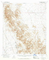
Castle Dome Mts, Arizona, USGS topographic map dated 1965.
Includes geographic coordinates (latitude and longitude). This topographic map is suitable for hiking, camping, and exploring, or framing it as a wall map.
Printed on-demand using high resolution imagery, on heavy weight and acid free paper, or alternatively on a variety of synthetic materials.
Topos available on paper, Waterproof, Poly, or Tyvek. Usually shipping rolled, unless combined with other folded maps in one order.
- Product Number: USGS-5547664
- Free digital map download (high-resolution, GeoPDF): Castle Dome Mts, Arizona (file size: 8 MB)
- Map Size: please refer to the dimensions of the GeoPDF map above
- Weight (paper map): ca. 55 grams
- Map Type: POD USGS Topographic Map
- Map Series: HTMC
- Map Verison: Historical
- Cell ID: 52260
- Scan ID: 314463
- Imprint Year: 1966
- Aerial Photo Year: 1962
- Field Check Year: 1965
- Datum: NAD27
- Map Projection: Polyconic
- Map published by United States Geological Survey
- Map Language: English
- Scanner Resolution: 600 dpi
- Map Cell Name: Castle Dome Mountains
- Grid size: 15 X 15 Minute
- Date on map: 1965
- Map Scale: 1:62500
- Geographical region: Arizona, United States
Neighboring Maps:
All neighboring USGS topo maps are available for sale online at a variety of scales.
Spatial coverage:
Topo map Castle Dome Mts, Arizona, covers the geographical area associated the following places:
- Kofa Deep Well - Thumb Peak - Big Eye Mine - Adams Well - Blue Rock Tank - McPherson Wash - Arch Tank - La Cholla Wash - Hollow Rock Tank - Robin Tank - Gravel Wash - Ketcherside Dam - Ladder Tank - McPherson Tank - Castle Rock Dam - Figueroa Tank - Bandy Tank - Castle Dome Mountains - Tinaja Sega - Thumb Butte - Keystone Mine - Hull Mine - Horse Tanks - Arch Tank Natural Bridge - Castle Dome Peak - Saguaro Tank - Colorado Mine - Doc Carter Spring - McPherson Pass - Hanging Tank - Virgin Basin - Little White Tanks - Red Tank - Black Tank - Chain Tank - Gray Tanks - Slumgullion Pass - Castle Rock Tank - Castle Dome Mine
- Map Area ID: AREA33.2533-114.25-114
- Northwest corner Lat/Long code: USGSNW33.25-114.25
- Northeast corner Lat/Long code: USGSNE33.25-114
- Southwest corner Lat/Long code: USGSSW33-114.25
- Southeast corner Lat/Long code: USGSSE33-114
- Northern map edge Latitude: 33.25
- Southern map edge Latitude: 33
- Western map edge Longitude: -114.25
- Eastern map edge Longitude: -114


