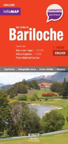
Bariloche, Argentina InfoMap by Zagier y Urruty
In the north of Patagonia, by a majestic lake and with the Andean Range in the background, the Latin American Ski Capital emerged. Founded in the early 20th century and with a remarkable European influence, Bariloche consolidated as a classic tourist destination in Argentina. Surrounded by the Nahuel Huapi National Park, its lakes, rivers, forests and mountains invite us to delve into nature and enjoy its landscapes throughout the year.
Features:
Map of San Carlos de Bariloche and surroundings, scale 1:160.000
(including lakes, ponds, rivers, creeks, islands; highlighting: roads, paths, shelters, ski resorts, waterfalls, view points, navigation; from Villa La Angostura in the North to Lago Mascardi in the South)
Detailed map of Parque Municipal Llao Llao
Detailed map of Villa La Angostura, scale 1:72.000
Map of San Carlos de Bariloche centre, scale 1:18.000
(highlighting: shopping areas, street markets, public buildings, churches, monuments, health centres, museums, traffic handedness).
Map Ruta de los 7 lagos, scale 1:270.000
(highlighting: roads, paths, lakes, waterfalls, view points, urban centres; from San Martín de los Andes in the North to Lago Mascardi in the South)
Mapa Región de los lagos, scale 1:750.000
(highlighting: roads, lakes, urban centres; from Lago Lolog in the North to El Bolsón in the South)
Information (architecture, nature, sports, gastronomy, highlights).
Facts for the visitor (distances, events calendar, holidays, transport, security, weather).
- Product Number: 2139128M
- Product Code: ZU_BARILOCHE
- ISBN: 9789872616120
- Year of Publication: 2013
- Folded Size: 8.27 x 3.94 inches
- Unfolded Size: 16.73 x 21.26 inches
- Map type: Folded Map
- Geographical region: Argentina