
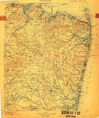
~ Navesink NJ topo map, 1:125000 scale, 30 X 30 Minute, Historical, 1902, updated 1912
Navesink, New Jersey, USGS topographic map dated 1902.
Includes geographic coordinates (latitude and longitude). This topographic map is suitable for hiking, camping, and exploring, or framing it as a wall map.
Printed on-demand using high resolution imagery, on heavy weight and acid free paper, or alternatively on a variety of synthetic materials.
Topos available on paper, Waterproof, Poly, or Tyvek. Usually shipping rolled, unless combined with other folded maps in one order.
- Product Number: USGS-8527891
- Free digital map download (high-resolution, GeoPDF): Navesink, New Jersey (file size: 9 MB)
- Map Size: please refer to the dimensions of the GeoPDF map above
- Weight (paper map): ca. 55 grams
- Map Type: POD USGS Topographic Map
- Map Series: HTMC
- Map Verison: Historical
- Cell ID: 66162
- Scan ID: 255440
- Imprint Year: 1912
- Survey Year: 1885
- Datum: Unstated
- Map Projection: Unstated
- Map published by United States Geological Survey
- Keywords: Overedge with No Adjacent Map
- Map Language: English
- Scanner Resolution: 600 dpi
- Map Cell Name: Navesink
- Grid size: 30 X 30 Minute
- Date on map: 1902
- Map Scale: 1:125000
- Geographical region: New Jersey, United States
Neighboring Maps:
All neighboring USGS topo maps are available for sale online at a variety of scales.
Spatial coverage:
Topo map Navesink, New Jersey, covers the geographical area associated the following places:
- Bricktown - Shore Road Estates - Cheesequake - Concordia - Smithburg - Spring Lake Heights - Gillilandtown - Monmouth Heights at Marlboro - Bergen Mills - Brookview - Centerville - Millhurst - Matawan - Larrabees - MacArthur Manor - Locust - Chestnut Estates - South Belmar - Bergerville - Laurelton Gardens - Lower Squankum - Oak Glen - Hendrickson Corners - Archertown - Wickatunk - Tiltons Corners - Algers Mills - Oak Hill - Camp Osborne - Greenville - Winston Park - Point Pleasant - Voorhees - Land of Pines - Englishtown - Farrington Lake Heights - Ely - Osbornsville - Oakhurst - Allaire - Jamesburg Gardens - Mechanicsville - Leonardo - Spring Valley - Van Marters Corner - Morgan Heights - Sayreville Junction - Archers Corner - Gordons Corner - Montrose - Deal Park - Fair Play - Somerset - Perrineville - Mantoloking Estates - Seven Stars - Herberts - Ocean Grove - Pleasant Valley - Holiday City - Applegarth - Melrose - Oakwood - Gillespie - Phalanx - Ernston - South River - Saint Vladimirs - Silverton Estates - Shrewsbury - Prospect Plains - Woodair Estates - Martins Landing - A Country Place - Tracy - Thomas J Dohany Homes - Holland - Tennent - Winding River Village - Maryland - Manalapan - North Centerville - Oakhurst Manor - Jerseyville - Atlantic Highlands - Moerls Corner - Runyon - Holmeson - Silverton - Arrowhead Village - Orchard Heights - Freewood Acres - Riviera Beach - Colts Neck - Vanderburg - Herbertsville - Hilton - Leisure Knoll - Wayside - Holmdel
- Map Area ID: AREA40.540-74.5-74
- Northwest corner Lat/Long code: USGSNW40.5-74.5
- Northeast corner Lat/Long code: USGSNE40.5-74
- Southwest corner Lat/Long code: USGSSW40-74.5
- Southeast corner Lat/Long code: USGSSE40-74
- Northern map edge Latitude: 40.5
- Southern map edge Latitude: 40
- Western map edge Longitude: -74.5
- Eastern map edge Longitude: -74


