
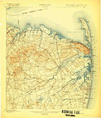
~ Sandy Hook NJ topo map, 1:62500 scale, 15 X 15 Minute, Historical, 1901, updated 1919
Sandy Hook, New Jersey, USGS topographic map dated 1901.
Includes geographic coordinates (latitude and longitude). This topographic map is suitable for hiking, camping, and exploring, or framing it as a wall map.
Printed on-demand using high resolution imagery, on heavy weight and acid free paper, or alternatively on a variety of synthetic materials.
Topos available on paper, Waterproof, Poly, or Tyvek. Usually shipping rolled, unless combined with other folded maps in one order.
- Product Number: USGS-8527108
- Free digital map download (high-resolution, GeoPDF): Sandy Hook, New Jersey (file size: 9 MB)
- Map Size: please refer to the dimensions of the GeoPDF map above
- Weight (paper map): ca. 55 grams
- Map Type: POD USGS Topographic Map
- Map Series: HTMC
- Map Verison: Historical
- Cell ID: 62116
- Scan ID: 255370
- Imprint Year: 1919
- Survey Year: 1884
- Datum: Unstated
- Map Projection: Unstated
- Map published by United States Geological Survey
- Keywords: Overedge
- Map Language: English
- Scanner Resolution: 600 dpi
- Map Cell Name: Sandy Hook
- Grid size: 15 X 15 Minute
- Date on map: 1901
- Map Scale: 1:62500
- Geographical region: New Jersey, United States
Neighboring Maps:
All neighboring USGS topo maps are available for sale online at a variety of scales.
Spatial coverage:
Topo map Sandy Hook, New Jersey, covers the geographical area associated the following places:
- Colts Neck - Bradevelt - Van Marters Corner - Holland - Oak Hill - Hillsdale - North Centerville - Burlington Heights - Montrose - Laurence Harbor - Smocks Corners - Oceanport - Natco - Orchard Estates - East Keansburg - Eatontown - Oceanic - Wertheins Corner - Chapel Hill - Little Silver - Port-au-Peck - West Long Branch - West Keansburg - Cooks Mills - Vanderburg - Deal Park - Union Beach - Wickatunk - Phalanx - Tinton Falls - Shrewsbury - Philips Mills - Bucks Mill - Keyport - Oakhurst Manor - Red Hill - Mount Pleasant - Leonardo - Leonardville - Sands Point - Elberon Park - Everett - Scobeyville - Morganville - Little Silver Point - Navesink - Matawan - Pleasant Valley Crossroads - Crawford Corners - New Monmouth - Cliffwood Beach - Port Monmouth - Cliffwood - Harmony - Wileys Corners - Stone Church - West Shrewsbury - Marlboro - Fair Haven - Dogs Corners - Monmouth Heights at Marlboro - Red Bank - Locust - Hazlet - Wayside - Oak Hill - Strathmore - Fairview - Belford - Pleasant Valley - North Middletown - Hilton - Centerville - Mechanicsville - Atlantic Highlands - Macedonia - Hendrickson Corners - Freneau - Pine Brook - Tiltons Corners - Town Brook - Holmdel - Keansburg - Lincroft - Oakhurst - Morrell Corners - Middletown - Fort Hancock - Monmouth Hills
- Map Area ID: AREA40.540.25-74.25-74
- Northwest corner Lat/Long code: USGSNW40.5-74.25
- Northeast corner Lat/Long code: USGSNE40.5-74
- Southwest corner Lat/Long code: USGSSW40.25-74.25
- Southeast corner Lat/Long code: USGSSE40.25-74
- Northern map edge Latitude: 40.5
- Southern map edge Latitude: 40.25
- Western map edge Longitude: -74.25
- Eastern map edge Longitude: -74


