
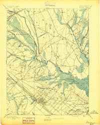
~ Mullica NJ topo map, 1:62500 scale, 15 X 15 Minute, Historical, 1894, updated 1894
Mullica, New Jersey, USGS topographic map dated 1894.
Includes geographic coordinates (latitude and longitude). This topographic map is suitable for hiking, camping, and exploring, or framing it as a wall map.
Printed on-demand using high resolution imagery, on heavy weight and acid free paper, or alternatively on a variety of synthetic materials.
Topos available on paper, Waterproof, Poly, or Tyvek. Usually shipping rolled, unless combined with other folded maps in one order.
- Product Number: USGS-8527062
- Free digital map download (high-resolution, GeoPDF): Mullica, New Jersey (file size: 6 MB)
- Map Size: please refer to the dimensions of the GeoPDF map above
- Weight (paper map): ca. 55 grams
- Map Type: POD USGS Topographic Map
- Map Series: HTMC
- Map Verison: Historical
- Cell ID: 53761
- Scan ID: 255286
- Imprint Year: 1894
- Survey Year: 1886
- Datum: Unstated
- Map Projection: Unstated
- Map published by United States Geological Survey
- Map Language: English
- Scanner Resolution: 600 dpi
- Map Cell Name: Egg Harbor
- Grid size: 15 X 15 Minute
- Date on map: 1894
- Map Scale: 1:62500
- Geographical region: New Jersey, United States
Neighboring Maps:
All neighboring USGS topo maps are available for sale online at a variety of scales.
Spatial coverage:
Topo map Mullica, New Jersey, covers the geographical area associated the following places:
- Dutchtown - South Egg Harbor - Weekstown - Atsion - Sweetwater - Clarks Landing - Pleasant Mills - Germania Gardens - Magnolia - Herman - Harrisville - Nesco - Egg Harbor City - Rockwood - Green Bank - Carmantown - Tylertown - Cologne - Germania - Jenkins - Charcoal Landing - West Egg Harbor - Maxwell - Clarks Mill - Bulltown - Wescoatville - Glouster Landing - Martha - Lower Bank - Washington - Gardiners Landing - Elwood - Unionville - Mount - Batsto - Lower Forge - Vienna Gardens - Wading River - Crowleytown - Devonshire
- Map Area ID: AREA39.7539.5-74.75-74.5
- Northwest corner Lat/Long code: USGSNW39.75-74.75
- Northeast corner Lat/Long code: USGSNE39.75-74.5
- Southwest corner Lat/Long code: USGSSW39.5-74.75
- Southeast corner Lat/Long code: USGSSE39.5-74.5
- Northern map edge Latitude: 39.75
- Southern map edge Latitude: 39.5
- Western map edge Longitude: -74.75
- Eastern map edge Longitude: -74.5


