
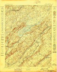
~ Hackettstown NJ topo map, 1:62500 scale, 15 X 15 Minute, Historical, 1898
Hackettstown, New Jersey, USGS topographic map dated 1898.
Includes geographic coordinates (latitude and longitude). This topographic map is suitable for hiking, camping, and exploring, or framing it as a wall map.
Printed on-demand using high resolution imagery, on heavy weight and acid free paper, or alternatively on a variety of synthetic materials.
Topos available on paper, Waterproof, Poly, or Tyvek. Usually shipping rolled, unless combined with other folded maps in one order.
- Product Number: USGS-8526952
- Free digital map download (high-resolution, GeoPDF): Hackettstown, New Jersey (file size: 10 MB)
- Map Size: please refer to the dimensions of the GeoPDF map above
- Weight (paper map): ca. 55 grams
- Map Type: POD USGS Topographic Map
- Map Series: HTMC
- Map Verison: Historical
- Cell ID: 54958
- Scan ID: 255208
- Survey Year: 1881
- Datum: Unstated
- Map Projection: Unstated
- Map published by United States Geological Survey
- Map Language: English
- Scanner Resolution: 600 dpi
- Map Cell Name: Hackettstown
- Grid size: 15 X 15 Minute
- Date on map: 1898
- Map Scale: 1:62500
- Geographical region: New Jersey, United States
Neighboring Maps:
All neighboring USGS topo maps are available for sale online at a variety of scales.
Spatial coverage:
Topo map Hackettstown, New Jersey, covers the geographical area associated the following places:
- Johnsonburg - Waterloo - Scrappy Corner - Allamuchy - Jacksonburg - Karrsville - Drakestown - Mount Lebanon - Washington - Ebenezer - Marble Hill - Blairstown - Townsbury - Villa Madonna - Febletown - Petersburg - Middle Valley - Brighton - Pequest - Anderson - Huntsburg - Great Meadows - Butler Park - Huntsville - Beattystown - Southtown - Alphano - Shiloh - Port Colden - Schooleys Mountain - Long Valley - Parker - Hackettstown - Saxton Falls - Pleasant Grove - Mount Bethel - Paulina - Greendell - Mount Hermon - Oxford - Kalarama - Hope - Springtown - Rockport - Tranquility - Penwell - Weirtown - Stephensburg - Port Murray - Marksboro - Long Bridge - Vienna - Swayzes Mills
- Map Area ID: AREA4140.75-75-74.75
- Northwest corner Lat/Long code: USGSNW41-75
- Northeast corner Lat/Long code: USGSNE41-74.75
- Southwest corner Lat/Long code: USGSSW40.75-75
- Southeast corner Lat/Long code: USGSSE40.75-74.75
- Northern map edge Latitude: 41
- Southern map edge Latitude: 40.75
- Western map edge Longitude: -75
- Eastern map edge Longitude: -74.75


