
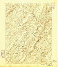
~ Franklin NJ topo map, 1:62500 scale, 15 X 15 Minute, Historical, 1888
Franklin, New Jersey, USGS topographic map dated 1888.
Includes geographic coordinates (latitude and longitude). This topographic map is suitable for hiking, camping, and exploring, or framing it as a wall map.
Printed on-demand using high resolution imagery, on heavy weight and acid free paper, or alternatively on a variety of synthetic materials.
Topos available on paper, Waterproof, Poly, or Tyvek. Usually shipping rolled, unless combined with other folded maps in one order.
- Product Number: USGS-8526910
- Free digital map download (high-resolution, GeoPDF): Franklin, New Jersey (file size: 8 MB)
- Map Size: please refer to the dimensions of the GeoPDF map above
- Weight (paper map): ca. 55 grams
- Map Type: POD USGS Topographic Map
- Map Series: HTMC
- Map Verison: Historical
- Cell ID: 54363
- Scan ID: 255171
- Survey Year: 1884
- Datum: Unstated
- Map Projection: Unstated
- Map published by United States Geological Survey
- Map Language: English
- Scanner Resolution: 600 dpi
- Map Cell Name: Franklin
- Grid size: 15 X 15 Minute
- Date on map: 1888
- Map Scale: 1:62500
- Geographical region: New Jersey, United States
Neighboring Maps:
All neighboring USGS topo maps are available for sale online at a variety of scales.
Spatial coverage:
Topo map Franklin, New Jersey, covers the geographical area associated the following places:
- Warbasse - Rudeville - Ogdensburg - Sussex Mills - Holland - Edison - Halsey - Pellettown - Russia - Plumbsock - Clearwater - Beaver Run - Beaver Lake - Stockholm - Wawayanda - Roys - Independence Corner - Hopkins Corner - Augusta - McAfee - Ackerson - Martins - Hardistonville - Lake Mohawk - Sparta - Beemerville - Houses Corner - Hamburg - Wantage - Lafayette - Ross Corner - Libertyville - Wykertown - Franklin - Harmonyvale - Petersburg - Northrup - Big Springs - Woodbourne - Mahola - Woodruffs Gap - Sussex - South Ogdensburg - Plains - McCoys Corner - Papakating - Monroe - Milton - Lewisburg - Sand Hills - Armstrong - Sparta Junction - Upper Mohawk - Hopewell - Pinkneyville
- Map Area ID: AREA41.2541-74.75-74.5
- Northwest corner Lat/Long code: USGSNW41.25-74.75
- Northeast corner Lat/Long code: USGSNE41.25-74.5
- Southwest corner Lat/Long code: USGSSW41-74.75
- Southeast corner Lat/Long code: USGSSE41-74.5
- Northern map edge Latitude: 41.25
- Southern map edge Latitude: 41
- Western map edge Longitude: -74.75
- Eastern map edge Longitude: -74.5


