
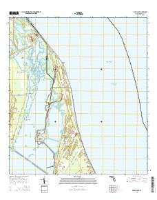
~ False Cape FL topo map, 1:24000 scale, 7.5 X 7.5 Minute, 2015
False Cape, Florida, USGS topographic map dated 2015.
Includes geographic coordinates (latitude and longitude). This topographic map is suitable for hiking, camping, and exploring, or framing it as a wall map.
Printed on-demand using high resolution imagery, on heavy weight and acid free paper, or alternatively on a variety of synthetic materials.
Topos available on paper, Waterproof, Poly, or Tyvek. Usually shipping rolled, unless combined with other folded maps in one order.
- Product Number: USGS-8002603
- Free digital map download (high-resolution, GeoPDF): False Cape, Florida (file size: 20 MB)
- Map Size: please refer to the dimensions of the GeoPDF map above
- Weight (paper map): ca. 55 grams
- Map Type: POD USGS Topographic Map
- Map Series: US Topo
- Map Verison: Current
- Cell ID: 14965
- Datum: North American Datum of 1983
- Map Projection: Transverse Mercator
- Map Cell Name: False Cape
- Grid size: 7.5 X 7.5 Minute
- Date on map: 2015
- Map Scale: 1:24000
- Geographical region: Florida, United States
Neighboring Maps:
All neighboring USGS topo maps are available for sale online at a variety of scales.
Spatial coverage:
Topo map False Cape, Florida, covers the geographical area associated the following places:
- Launch Complex 40 - Jack Davis Cut - Gator Hole - Launch Complex 37 - Tea Creek Cutoff - Launch Complex 19 - Launch Complex 34 - Tea Hammock - Futch Point - De Soto Beach (historical) - Jack Davis Island - Broadaxe Creek - Hamper Hammock - Whites Point - False Cape - Pepper Hammock - Pepper Flats - Chester Shoal - Harrison Island - Titusville Beach - Devils Elbow - Pintail Creek - Tea Creek - Barge Channel - Bluebill Creek - Conrad Creek - Harrison Road Creek - Launch Complex 39B - East Pepper Creek - East Conrad Creek - Gulbrandson Creek - Launch Complex 41 - Launch Complex 20 - West Pepper Creek - Launch Complex 16
- Map Area ID: AREA28.62528.5-80.625-80.5
- Northwest corner Lat/Long code: USGSNW28.625-80.625
- Northeast corner Lat/Long code: USGSNE28.625-80.5
- Southwest corner Lat/Long code: USGSSW28.5-80.625
- Southeast corner Lat/Long code: USGSSE28.5-80.5
- Northern map edge Latitude: 28.625
- Southern map edge Latitude: 28.5
- Western map edge Longitude: -80.625
- Eastern map edge Longitude: -80.5


