
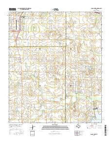
~ Sloop Creek TX topo map, 1:24000 scale, 7.5 X 7.5 Minute, 2016
Sloop Creek, Texas, USGS topographic map dated 2016.
Includes geographic coordinates (latitude and longitude). This topographic map is suitable for hiking, camping, and exploring, or framing it as a wall map.
Printed on-demand using high resolution imagery, on heavy weight and acid free paper, or alternatively on a variety of synthetic materials.
Topos available on paper, Waterproof, Poly, or Tyvek. Usually shipping rolled, unless combined with other folded maps in one order.
- Product Number: USGS-7924285
- Free digital map download (high-resolution, GeoPDF): Sloop Creek, Texas (file size: 23 MB)
- Map Size: please refer to the dimensions of the GeoPDF map above
- Weight (paper map): ca. 55 grams
- Map Type: POD USGS Topographic Map
- Map Series: US Topo
- Map Verison: Current
- Cell ID: 41733
- Datum: North American Datum of 1983
- Map Projection: Transverse Mercator
- Map Cell Name: Sloop Creek
- Grid size: 7.5 X 7.5 Minute
- Date on map: 2016
- Map Scale: 1:24000
- Geographical region: Texas, United States
Neighboring Maps:
All neighboring USGS topo maps are available for sale online at a variety of scales.
Spatial coverage:
Topo map Sloop Creek, Texas, covers the geographical area associated the following places:
- Vogtsberger Oil Field - McGregor Ranch Lake Number 1 - Wesley United Methodist Church - Lake Arrowhead State Park Trail - Sloop Creek - Lake Arrowhead State Park - Keith Ranch - Kickapoo Downtown Airport - Lee Lake - McGregor Ranch - Trinity Baptist Church - Vogtsberger Ranch - B and P Lake Number 2 - B and P Lake Number 1 Dam - McGregor Ranch Lake Number 1 Dam - McGregor Ranch Lake Number 2 Dam - Texas No Name Number 41 Dam - Rathgeber Ranch - Lee Lake Dam - B and P Lake Number 2 Dam - Fain Elementary School - Hursh Park - Loch Lomond Park - Avis Ranch - HealthSouth Rehabilitation Hospital of Wichita Falls - Southern Hills Park - McGregor Ranch Lake Number 2 - Jentsch Ranch - Sloop Pond - North Star School - Norris Ranch - Cook Ranch - Arrowhead Ranch Estates Volunteer Fire Department - Lake Number 1
- Map Area ID: AREA33.87533.75-98.5-98.375
- Northwest corner Lat/Long code: USGSNW33.875-98.5
- Northeast corner Lat/Long code: USGSNE33.875-98.375
- Southwest corner Lat/Long code: USGSSW33.75-98.5
- Southeast corner Lat/Long code: USGSSE33.75-98.375
- Northern map edge Latitude: 33.875
- Southern map edge Latitude: 33.75
- Western map edge Longitude: -98.5
- Eastern map edge Longitude: -98.375


