
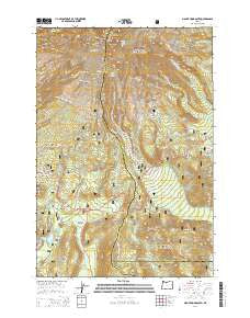
~ Mount Hood South OR topo map, 1:24000 scale, 7.5 X 7.5 Minute, Current, 2014
Mount Hood South, Oregon, USGS topographic map dated 2014.
Includes geographic coordinates (latitude and longitude). This topographic map is suitable for hiking, camping, and exploring, or framing it as a wall map.
Printed on-demand using high resolution imagery, on heavy weight and acid free paper, or alternatively on a variety of synthetic materials.
Topos available on paper, Waterproof, Poly, or Tyvek. Usually shipping rolled, unless combined with other folded maps in one order.
- Product Number: USGS-7253460
- Free digital map download (high-resolution, GeoPDF): Mount Hood South, Oregon (file size: 39 MB)
- Map Size: please refer to the dimensions of the GeoPDF map above
- Weight (paper map): ca. 55 grams
- Map Type: POD USGS Topographic Map
- Map Series: US Topo
- Map Verison: Current
- Cell ID: 30638
- Datum: North American Datum of 1983
- Map Projection: Transverse Mercator
- Map Cell Name: Mount Hood South
- Grid size: 7.5 X 7.5 Minute
- Date on map: 2014
- Map Scale: 1:24000
- Geographical region: Oregon, United States
Neighboring Maps:
All neighboring USGS topo maps are available for sale online at a variety of scales.
Spatial coverage:
Topo map Mount Hood South, Oregon, covers the geographical area associated the following places:
- Alpine Recreation Site - Mount Hood - Gnarl Ridge Trail - Crater Rock - The Chimney - Illumination Rock - Bird Butte - Lamberson Butte - Mount Hood Meadows Oregon Wastewater Treatment Plant - Newton Clark Glacier - Trillium Lake Dam - Barlow Guard Station - Devils Half Acre Meadow - Umbrella Falls - Barlow Ridge - Mud Creek Quarry - Hood River Meadows - Swim (historical) - Mineral Creek - Hawkins Ridge - North Fork Mineral Creek - Summit Meadows - Gnarl Ridge - Palmateer Creek - Barlow Pass - Triangle Moraine - Government Camp Safety Rest Area - Umbrella Falls Trail - West Fork Salmon River - Trillium Lake Boat Ramp - Mount Hood Wilderness - Zigzag Glacier - Hot Rocks - Barlow Butte - Trillium Lake - Mitchell Creek - Reid Glacier - Salmon River Campground - Swim Creek - Mono Creek - Paradise Park Shelter - Steel Cliff - Summit Meadows Cemetery - Coalman Glacier - Sahale Falls - Leuthold Couloir - Teacup Lake - Red Top Meadow - Devils Kitchen - Glade Ski Trail - Devils Half Acre Meadow Recreation Site - Switchback Falls - Buzzard Point - Pioneer Woman's Grave - White River Sand Pit - South Fork Mineral Creek - Silcox Hut - Alpine Ski Trail - Mount Hood Meadows Ski Resort - Timberline Lodge Post Office - East Fork Salmon River - White River Park Campground - Green Apple Creek - White River Glacier - Palmateer Meadows - Still Creek Recreation Site - Snow Bunny Lodge - Timberline Post Office (historical) - Mississippi Head - Pucci Glade - Phlox Point Recreation Site - Nanitch Campground - Summit Ranger Station - Bennett Pass - Trillium Lake Recreation Site - Camp Blossom - South Fork Iron Creek - Swim Post Office (historical) - North Fork Iron Creek - Palmer Glacier - Timberline Lodge
- Map Area ID: AREA45.37545.25-121.75-121.625
- Northwest corner Lat/Long code: USGSNW45.375-121.75
- Northeast corner Lat/Long code: USGSNE45.375-121.625
- Southwest corner Lat/Long code: USGSSW45.25-121.75
- Southeast corner Lat/Long code: USGSSE45.25-121.625
- Northern map edge Latitude: 45.375
- Southern map edge Latitude: 45.25
- Western map edge Longitude: -121.75
- Eastern map edge Longitude: -121.625


