
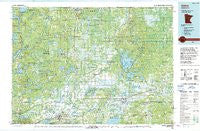
~ Aitkin MN topo map, 1:100000 scale, 30 X 60 Minute, Historical, 1994, updated 1994
Aitkin, Minnesota, USGS topographic map dated 1994.
Includes geographic coordinates (latitude and longitude). This topographic map is suitable for hiking, camping, and exploring, or framing it as a wall map.
Printed on-demand using high resolution imagery, on heavy weight and acid free paper, or alternatively on a variety of synthetic materials.
Topos available on paper, Waterproof, Poly, or Tyvek. Usually shipping rolled, unless combined with other folded maps in one order.
- Product Number: USGS-5985186
- Free digital map download (high-resolution, GeoPDF): Aitkin, Minnesota (file size: 19 MB)
- Map Size: please refer to the dimensions of the GeoPDF map above
- Weight (paper map): ca. 55 grams
- Map Type: POD USGS Topographic Map
- Map Series: HTMC
- Map Verison: Historical
- Cell ID: 67019
- Scan ID: 805547
- Imprint Year: 1994
- Woodland Tint: Yes
- Aerial Photo Year: 1992
- Edit Year: 1994
- Datum: NAD27
- Map Projection: Universal Transverse Mercator
- Map published by United States Geological Survey
- Map Language: English
- Scanner Resolution: 508 dpi
- Map Cell Name: Aitkin
- Grid size: 30 X 60 Minute
- Date on map: 1994
- Map Scale: 1:100000
- Geographical region: Minnesota, United States
Neighboring Maps:
All neighboring USGS topo maps are available for sale online at a variety of scales.
Spatial coverage:
Topo map Aitkin, Minnesota, covers the geographical area associated the following places:
- Lawler - Palisade - Outing - Libby - Grayling - Waukenabo - Shovel Lake - Emily - Hill City - Waldeck - East Lake - McGregor - Mae - Kimberly - Balsam - Rossburg - Minnewawa - Wolford - Bain - Haypoint - Pine Knoll - Ball Bluff - Wright - Hassman - Automba - Welshons Company Mobile Home Park - Island - Cuyuna - Little Pine - Tamarack - Hartley Spur - Aitkin - Swatara - Rabey (historical) - Sheshebee
- Map Area ID: AREA4746.5-94-93
- Northwest corner Lat/Long code: USGSNW47-94
- Northeast corner Lat/Long code: USGSNE47-93
- Southwest corner Lat/Long code: USGSSW46.5-94
- Southeast corner Lat/Long code: USGSSE46.5-93
- Northern map edge Latitude: 47
- Southern map edge Latitude: 46.5
- Western map edge Longitude: -94
- Eastern map edge Longitude: -93


