
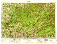
~ Warren PA topo map, 1:250000 scale, 1 X 2 Degree, Historical, 1959, updated 1959
Warren, Pennsylvania, USGS topographic map dated 1959.
Includes geographic coordinates (latitude and longitude). This topographic map is suitable for hiking, camping, and exploring, or framing it as a wall map.
Printed on-demand using high resolution imagery, on heavy weight and acid free paper, or alternatively on a variety of synthetic materials.
Topos available on paper, Waterproof, Poly, or Tyvek. Usually shipping rolled, unless combined with other folded maps in one order.
- Product Number: USGS-5931787
- Free digital map download (high-resolution, GeoPDF): Warren, Pennsylvania (file size: 25 MB)
- Map Size: please refer to the dimensions of the GeoPDF map above
- Weight (paper map): ca. 55 grams
- Map Type: POD USGS Topographic Map
- Map Series: HTMC
- Map Verison: Historical
- Cell ID: 69086
- Scan ID: 462111
- Imprint Year: 1959
- Woodland Tint: Yes
- Datum: Unstated
- Map Projection: Transverse Mercator
- Map published by United States Geological Survey
- Map published by United States Army Corps of Engineers
- Map published by United States Army
- Map Language: English
- Scanner Resolution: 600 dpi
- Map Cell Name: Warren
- Grid size: 1 X 2 Degree
- Date on map: 1959
- Map Scale: 1:250000
- Geographical region: Pennsylvania, United States
Neighboring Maps:
All neighboring USGS topo maps are available for sale online at a variety of scales.
Spatial coverage:
Topo map Warren, Pennsylvania, covers the geographical area associated the following places:
- Sanford - Pittsfield - Huefner - Muzette - Straight Creek - Custer City - Five Points - Forest Chapel - Taintor - Glen Hazel - Dahoga - Highland Corners - Wallace Corners - Sykesville - Sugar Run (historical) - Foster Brook - Pearl - Colegrove - Trunkeyville - Boyers - Columbus - Cramer - Helen Mills - Preston - Sunville - Beechwoods - Degolia - Summerville - Rocky Grove - Paint Mills - Clarion Junction - Narrows Creek - Hazelton Mills - Hallston - Marshburg - Elk City - Clermont - Stanton - Surveyor - Karthaus - Dempseytown - Whig Hill - Nansen - Eagle Rock - Little Cooley - Anderson - Day - Canal Center - Honeoye - Betula - Prentisvale - Beechtree - Kahletown - Lincolnville - Snively Corners - Gresham - Pansy - Henrys Bend - Coulter - Reno - Twin Churchs - Nineveh - Kanesholm - Millers Station - Shelander Hollow - Brockway - Marienville - Mystic Park - Chestnut Grove - Brown Hill - Mill Village - Blowtown - Toonerville - Congress Hill - Sherwin - Tyler - Sterling Run - East Hickory - Campbelltown - Eldred Center - Winterburn - Bingham - Hoover - Swissmont - Whiskerville - Piper - Salem - McGarey - Grant - Sinnemahoning - Sandy Hollow - Rockton - Concord - Smith Summit - Sugar Hill - Egypt - Cyrus - Haymaker - Wildcat - Jackson Crossing
- Map Area ID: AREA4241-80-78
- Northwest corner Lat/Long code: USGSNW42-80
- Northeast corner Lat/Long code: USGSNE42-78
- Southwest corner Lat/Long code: USGSSW41-80
- Southeast corner Lat/Long code: USGSSE41-78
- Northern map edge Latitude: 42
- Southern map edge Latitude: 41
- Western map edge Longitude: -80
- Eastern map edge Longitude: -78


