
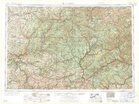
~ Warren PA topo map, 1:250000 scale, 1 X 2 Degree, Historical, 1958
Warren, Pennsylvania, USGS topographic map dated 1958.
Includes geographic coordinates (latitude and longitude). This topographic map is suitable for hiking, camping, and exploring, or framing it as a wall map.
Printed on-demand using high resolution imagery, on heavy weight and acid free paper, or alternatively on a variety of synthetic materials.
Topos available on paper, Waterproof, Poly, or Tyvek. Usually shipping rolled, unless combined with other folded maps in one order.
- Product Number: USGS-5931781
- Free digital map download (high-resolution, GeoPDF): Warren, Pennsylvania (file size: 25 MB)
- Map Size: please refer to the dimensions of the GeoPDF map above
- Weight (paper map): ca. 55 grams
- Map Type: POD USGS Topographic Map
- Map Series: HTMC
- Map Verison: Historical
- Cell ID: 69086
- Scan ID: 462044
- Woodland Tint: Yes
- Datum: Unstated
- Map Projection: Transverse Mercator
- Map published by United States Army Corps of Engineers
- Map published by United States Army
- Map Language: English
- Scanner Resolution: 600 dpi
- Map Cell Name: Warren
- Grid size: 1 X 2 Degree
- Date on map: 1958
- Map Scale: 1:250000
- Geographical region: Pennsylvania, United States
Neighboring Maps:
All neighboring USGS topo maps are available for sale online at a variety of scales.
Spatial coverage:
Topo map Warren, Pennsylvania, covers the geographical area associated the following places:
- Reno - Hastings - Pilgrimham - Beuhler Corner - Niles - Sheffield - Marble - Sizerville - Newmansville - Hilldale - Bully Hill - Maple Grove - Desire - Goshen - Sugar Run (historical) - Whiskerville - Gallows Harbor - Rynd Farm - Frenchville - Larabee - Colegrove - Brookville - Jefferson - Du Bois - Cortez - Alcola - Cartwright - Detwood - Rouseville - Walkertown - Hyde - Piper - Nineveh - Walsh - Mount Joy - Kersey - Petrolia - East Shamburg - Kohlmeyer Corner - Monterey - Coneville - Weber City - Burtville - Drifting - Plumer - Oak Ridge - Bela - Sandy Hollow - Kossuth - Prentisvale - Millville - Forest Chapel - Marshburg - North Pine Grove - Corydon (historical) - Pardus - Hoover - Shamburg - Baxter - Russell City - Lewis Run - Perryville - Barrett - Worthville - Green Oaks - Bullis Mills - Weldbank - Colonial Village - Kaneville - Colza - Trunkeyville - Munderf - Atwells Crossing - Callensburg - Helvetia - Tryonville - Rockland - Kane - Troy - Ferris Corners - Knox Dale - Parsonville - Greendale - Dawson Run - Gouldtown - Scattertown - Rockton - Saint George - Medix Run - South Sulger (historical) - Barnes - Day - Elk City - Corduroy - Austin - Curllsville - Lander - Penfield - Hollywood - Four Points
- Map Area ID: AREA4241-80-78
- Northwest corner Lat/Long code: USGSNW42-80
- Northeast corner Lat/Long code: USGSNE42-78
- Southwest corner Lat/Long code: USGSSW41-80
- Southeast corner Lat/Long code: USGSSE41-78
- Northern map edge Latitude: 42
- Southern map edge Latitude: 41
- Western map edge Longitude: -80
- Eastern map edge Longitude: -78


