
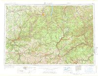
~ Warren PA topo map, 1:250000 scale, 1 X 2 Degree, Historical, 1971
Warren, Pennsylvania, USGS topographic map dated 1971.
Includes geographic coordinates (latitude and longitude). This topographic map is suitable for hiking, camping, and exploring, or framing it as a wall map.
Printed on-demand using high resolution imagery, on heavy weight and acid free paper, or alternatively on a variety of synthetic materials.
Topos available on paper, Waterproof, Poly, or Tyvek. Usually shipping rolled, unless combined with other folded maps in one order.
- Product Number: USGS-5931779
- Free digital map download (high-resolution, GeoPDF): Warren, Pennsylvania (file size: 19 MB)
- Map Size: please refer to the dimensions of the GeoPDF map above
- Weight (paper map): ca. 55 grams
- Map Type: POD USGS Topographic Map
- Map Series: HTMC
- Map Verison: Historical
- Cell ID: 69086
- Scan ID: 462043
- Woodland Tint: Yes
- Aerial Photo Year: 1956
- Edit Year: 1969
- Datum: Unstated
- Map Projection: Transverse Mercator
- Map published by United States Geological Survey
- Map Language: English
- Scanner Resolution: 600 dpi
- Map Cell Name: Warren
- Grid size: 1 X 2 Degree
- Date on map: 1971
- Map Scale: 1:250000
- Geographical region: Pennsylvania, United States
Neighboring Maps:
All neighboring USGS topo maps are available for sale online at a variety of scales.
Spatial coverage:
Topo map Warren, Pennsylvania, covers the geographical area associated the following places:
- Monroe - Paint Mills - Reynoldsville - Spring Creek - Hazelton Mills - Congress Hill - West Spring Creek - Force - Glade - Shannondale - Kimble Corners - Du Bois - Port Barnett - Venturetown - Takitezy - Winterburn - Gardeau - Palestine - Day - Henderson Station - Wrights Corners - Cherrytree - Williamsville - Iron City - Ahrensville - Baney Settlement - Cameron - Wallaceville - McLaughlin Corners - Boyers - Four Corners - Brandy Camp - Nicklin - Weldbank - Durward - Big Shanty - Curllsville - Hebron Center - Shamburg - Smith Summit - Eden - Hydetown - Little Hickory - Starbrick - Sanford - Ohl - Riverview - Gelnett - Shipmans Eddy - Sabula - Rimersburg - Walton - Jackson Crossing - Wigwam - Columbus - Nineveh - Green Valley - Fryburg - Tyler - Truman - Kanesholm - Lawrenceburg - Waterford - Marienville - Arbuckle - German Settlement - Hazel Hurst - Ormsby - Dawson Run - Pancoast - Dallas City - Balltown - Guffey - Starr - East Branch - Dents Run - Coal Hollow - Luces Corners - Squab Hollow - Rolling Stone - Clermont - Mount Pleasant - Inez - Hallston - Annandale - Beechwood - Pilgrimham - Coal Glen - Schoffner Corner - Hermit Spring - Mariasville - Brinkerton - Sugar Run (historical) - Blue Jay - Bullis Mills - Kingsville - Helvetia - Liberty - McKinley - Big Bend
- Map Area ID: AREA4241-80-78
- Northwest corner Lat/Long code: USGSNW42-80
- Northeast corner Lat/Long code: USGSNE42-78
- Southwest corner Lat/Long code: USGSSW41-80
- Southeast corner Lat/Long code: USGSSE41-78
- Northern map edge Latitude: 42
- Southern map edge Latitude: 41
- Western map edge Longitude: -80
- Eastern map edge Longitude: -78


