
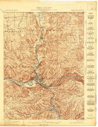
~ Warren PA topo map, 1:62500 scale, 15 X 15 Minute, Historical, 1907
Warren, Pennsylvania, USGS topographic map dated 1907.
Includes geographic coordinates (latitude and longitude). This topographic map is suitable for hiking, camping, and exploring, or framing it as a wall map.
Printed on-demand using high resolution imagery, on heavy weight and acid free paper, or alternatively on a variety of synthetic materials.
Topos available on paper, Waterproof, Poly, or Tyvek. Usually shipping rolled, unless combined with other folded maps in one order.
- Product Number: USGS-5931777
- Free digital map download (high-resolution, GeoPDF): Warren, Pennsylvania (file size: 12 MB)
- Map Size: please refer to the dimensions of the GeoPDF map above
- Weight (paper map): ca. 55 grams
- Map Type: POD USGS Topographic Map
- Map Series: HTMC
- Map Verison: Historical
- Cell ID: 64240
- Scan ID: 461952
- Survey Year: 1907
- Datum: Unstated
- Map Projection: Unstated
- Map published by United States Geological Survey
- Map Language: English
- Scanner Resolution: 600 dpi
- Map Cell Name: Warren
- Grid size: 15 X 15 Minute
- Date on map: 1907
- Map Scale: 1:62500
- Geographical region: Pennsylvania, United States
Neighboring Maps:
All neighboring USGS topo maps are available for sale online at a variety of scales.
Spatial coverage:
Topo map Warren, Pennsylvania, covers the geographical area associated the following places:
- Venturetown - Gouldtown - Warren - Jackson Run - Akeley - South Warren - Big Bend - Buchers Mills - Shipmans Eddy - North Warren - Putnamville - Jackson Crossing - Stoneham - Hazeltine Corners - Weldbank - Lander - Old Clarendon - Russell - Hemlock - Cable Hollow - Rogertown - Scandia - Backup Corners - Starbrick - Grunderville (historical) - Clarendon - Clarendon Heights - East Warren - Glade
- Map Area ID: AREA4241.75-79.25-79
- Northwest corner Lat/Long code: USGSNW42-79.25
- Northeast corner Lat/Long code: USGSNE42-79
- Southwest corner Lat/Long code: USGSSW41.75-79.25
- Southeast corner Lat/Long code: USGSSE41.75-79
- Northern map edge Latitude: 42
- Southern map edge Latitude: 41.75
- Western map edge Longitude: -79.25
- Eastern map edge Longitude: -79


