
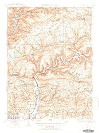
~ Warrensville PA topo map, 1:62500 scale, 15 X 15 Minute, Historical, 1930
Warrensville, Pennsylvania, USGS topographic map dated 1930.
Includes geographic coordinates (latitude and longitude). This topographic map is suitable for hiking, camping, and exploring, or framing it as a wall map.
Printed on-demand using high resolution imagery, on heavy weight and acid free paper, or alternatively on a variety of synthetic materials.
Topos available on paper, Waterproof, Poly, or Tyvek. Usually shipping rolled, unless combined with other folded maps in one order.
- Product Number: USGS-5931771
- Free digital map download (high-resolution, GeoPDF): Warrensville, Pennsylvania (file size: 8 MB)
- Map Size: please refer to the dimensions of the GeoPDF map above
- Weight (paper map): ca. 55 grams
- Map Type: POD USGS Topographic Map
- Map Series: HTMC
- Map Verison: Historical
- Cell ID: 64246
- Scan ID: 462045
- Survey Year: 1930
- Datum: NAD
- Map Projection: Polyconic
- Map published by United States Geological Survey
- Map Language: English
- Scanner Resolution: 600 dpi
- Map Cell Name: Warrensville
- Grid size: 15 X 15 Minute
- Date on map: 1930
- Map Scale: 1:62500
- Geographical region: Pennsylvania, United States
Neighboring Maps:
All neighboring USGS topo maps are available for sale online at a variety of scales.
Spatial coverage:
Topo map Warrensville, Pennsylvania, covers the geographical area associated the following places:
- Barbours - Huntersville - Marsh Hill - Dewey Corner - Loyalsockville - Montoursville - Butternut Grove - Farragut - Wallis Run - Calvert - North Eldred - Bodines - Kenmar - Proctor - Kellyburg - Penn Vale - Warrensville - Hoppestown
- Map Area ID: AREA41.541.25-77-76.75
- Northwest corner Lat/Long code: USGSNW41.5-77
- Northeast corner Lat/Long code: USGSNE41.5-76.75
- Southwest corner Lat/Long code: USGSSW41.25-77
- Southeast corner Lat/Long code: USGSSE41.25-76.75
- Northern map edge Latitude: 41.5
- Southern map edge Latitude: 41.25
- Western map edge Longitude: -77
- Eastern map edge Longitude: -76.75


