
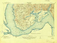
~ Nanjemoy MD topo map, 1:62500 scale, 15 X 15 Minute, Historical, 1913, updated 1945
Nanjemoy, Maryland, USGS topographic map dated 1913.
Includes geographic coordinates (latitude and longitude). This topographic map is suitable for hiking, camping, and exploring, or framing it as a wall map.
Printed on-demand using high resolution imagery, on heavy weight and acid free paper, or alternatively on a variety of synthetic materials.
Topos available on paper, Waterproof, Poly, or Tyvek. Usually shipping rolled, unless combined with other folded maps in one order.
- Product Number: USGS-5689364
- Free digital map download (high-resolution, GeoPDF): Nanjemoy, Maryland (file size: 9 MB)
- Map Size: please refer to the dimensions of the GeoPDF map above
- Weight (paper map): ca. 55 grams
- Map Type: POD USGS Topographic Map
- Map Series: HTMC
- Map Verison: Historical
- Cell ID: 396037
- Scan ID: 257534
- Imprint Year: 1945
- Survey Year: 1911
- Datum: NAD
- Map Projection: Polyconic
- Map published by United States Geological Survey
- Keywords: Overedge
- Map Language: English
- Scanner Resolution: 600 dpi
- Map Cell Name: Nanjemoy
- Grid size: 15 X 15 Minute
- Date on map: 1913
- Map Scale: 1:62500
- Geographical region: Maryland, United States
Neighboring Maps:
All neighboring USGS topo maps are available for sale online at a variety of scales.
Spatial coverage:
Topo map Nanjemoy, Maryland, covers the geographical area associated the following places:
- Potomac Knolls - Riverside - Dartmoor - Welcome Acres - Montague Landing - Nanjemoy - Maryland Point - Lyons Den - Biscoe - Hampstead - Grayton - Owens - Somerset Beach - Uly Brooks - Wellington Beach - Thorny Point Farm - Brentland - Loy Landing - Estates of Widewater Pond - Potomac Shores - Compton - Cedar Grove - Potomac Overlook - Simms Landing - Marshope - Willamsburg on the Potomac - Widewater Beach - Hooes - Hickory Hill - Ironsides - Canterbury Estates - Liverpool Wharf - Friendship Acres - Brooke Ridge - Mount Air - Hill Top - Penn Manor - Mount Hope - Belvedere Beach - Grafton (historical) - Bristol (historical) - Doncaster - Cherryfield (historical) - Chapel Point - Melody Acres - Jacksontown (historical) - Sutton Acres - Japazaws - Widewater - Marlboro - Berthaville - Green Manor Estates
- Map Area ID: AREA38.538.3333333-77.3333333-77
- Northwest corner Lat/Long code: USGSNW38.5-77.3333333
- Northeast corner Lat/Long code: USGSNE38.5-77
- Southwest corner Lat/Long code: USGSSW38.3333333-77.3333333
- Southeast corner Lat/Long code: USGSSE38.3333333-77
- Northern map edge Latitude: 38.5
- Southern map edge Latitude: 38.3333333
- Western map edge Longitude: -77.3333333
- Eastern map edge Longitude: -77


