
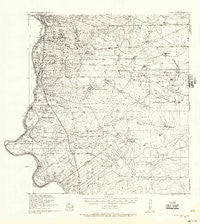
~ Becerra Creek TX topo map, 1:62500 scale, 15 X 15 Minute, Historical, 1933, updated 1956
Becerra Creek, Texas, USGS topographic map dated 1933.
Includes geographic coordinates (latitude and longitude). This topographic map is suitable for hiking, camping, and exploring, or framing it as a wall map.
Printed on-demand using high resolution imagery, on heavy weight and acid free paper, or alternatively on a variety of synthetic materials.
Topos available on paper, Waterproof, Poly, or Tyvek. Usually shipping rolled, unless combined with other folded maps in one order.
- Product Number: USGS-5686599
- Free digital map download (high-resolution, GeoPDF): Becerra Creek, Texas (file size: 7 MB)
- Map Size: please refer to the dimensions of the GeoPDF map above
- Weight (paper map): ca. 55 grams
- Map Type: POD USGS Topographic Map
- Map Series: HTMC
- Map Verison: Historical
- Cell ID: 51317
- Scan ID: 105806
- Imprint Year: 1956
- Visual Version Number: 1
- Edit Year: 1933
- Survey Year: 1929
- Datum: NAD
- Map Projection: Polyconic
- Map published by United States Army Corps of Engineers
- Keywords: Nonstandard Press Run; Overedge with No Adjacent Map
- Map Language: English
- Scanner Resolution: 600 dpi
- Map Cell Name: Becerra Creek
- Grid size: 15 X 15 Minute
- Date on map: 1933
- Map Scale: 1:62500
- Geographical region: Texas, United States
Neighboring Maps:
All neighboring USGS topo maps are available for sale online at a variety of scales.
Spatial coverage:
Topo map Becerra Creek, Texas, covers the geographical area associated the following places:
- Ranchitos 359 East Colonia - Dolores Colonia - Laredo Ranchettes Colonia - Rio Bravo Annex Colonia - Los Altos Colonia - Pueblo Nuevo - Pueblo Nuevo Colonia - La Presa - La Presa Colonia - Old Milwaukee West Colonia - San Carlos Number 2 Colonia - San Carlos Number 1 Colonia - D-5 Acres Colonia - Rio Bravo Colonia - Las Blancas Colonia - Larga Vista Colonia - El Cenizo - Rio Bravo - Larga Vista - Tanquecitos South Acres Colonia - Laredo Ranchettes - One River Place Colonia - Old Milwaukee East Colonia
- Map Area ID: AREA27.527.25-99.5-99.25
- Northwest corner Lat/Long code: USGSNW27.5-99.5
- Northeast corner Lat/Long code: USGSNE27.5-99.25
- Southwest corner Lat/Long code: USGSSW27.25-99.5
- Southeast corner Lat/Long code: USGSSE27.25-99.25
- Northern map edge Latitude: 27.5
- Southern map edge Latitude: 27.25
- Western map edge Longitude: -99.5
- Eastern map edge Longitude: -99.25


